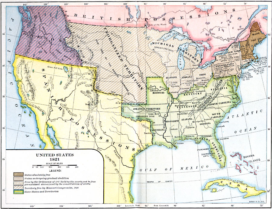
Description: A map of the United States and territories in 1821 after the Missouri Compromise, showing the Free States and territories, the Slave States and territories, and the transitional territories at the time. The map is color–coded to show the States absolutely free (Maine, Vermont, New Hampshire, and Massachusetts), the States undergoing gradual abolition (New York, Connecticut, Rhode Island, New Jersey, and Pennsylvania), Free by the Ordinance of 1787 (held by the courts not to free pre–existent slaves) and by the constitutions of the states (Illinois, Indiana, Ohio, and the Michigan Territory), territory free by the Missouri Compromise of 1820 (Unorganized Territory of the Louisiana Purchase), and the Slave States and territories (Delaware, Maryland, Virginia, Kentucky, Missouri, Arkansas Territory, Tennessee, North Carolina, South Carolina, Georgia, Alabama, Mississippi, Louisiana, and the Florida Territory). The map also shows the disputed territory in northern Maine, the Oregon Country occupied jointly by the British and the United States, and the boundary of Spanish possessions established in 1819. This map notes dates of abolition, dates of territorial organization, and the numbers of slaves in areas of gradual abolition or under the Ordinance of 1787.
Place Names: Growth of Nation, Bahamas, �Cuba, �Canada, �Mexico, �United States, �slave states, �free states, �civil wa
ISO Topic Categories: boundaries,
inlandWaters,
location,
oceans
Keywords: United States, physical, �political, physical features, country borders,
major political subdivisions, boundaries,
inlandWaters,
location,
oceans, Unknown, 1821
Source: Albert Bushnell Hart, LL.D., The American Nation Vol 14 (New York, NY: Harper and Brothers, 1906) 6
Map Credit: Courtesy the private collection of Roy Winkelman |
|