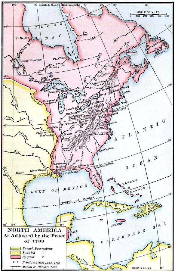
Description: A map of eastern North America and the Greater Antilles showing the territorial possessions adjusted by the Peace of 1763 (Treaty of Paris) at the end of the French and Indian War (and the Seven Year War in Europe). The map is color–coded to show the possessions in the region of the France (Haiti), Spain, and Britain at the time. The map shows the Proclamation Line established in 1763 between the English Colonies and the Indian Territory west of the Appalachian Mountains, East and West Florida, and Quebec. Also shown is the Mason and Dixon line, surveyed to resolve boundary disputes between the Pennsylvania, Maryland, and Delaware colonies. Settlements, forts, and battle sites of the French and Indian War are shown.
Place Names: A Regional Map of North America, Canada, �United States, �Cuba, �Mexico, �Haiti, �San Domingo, �Beliz
ISO Topic Categories: boundaries,
inlandWaters,
location,
oceans
Keywords: North America, physical, �political, kCaribbean, physical features, local jurisdictions, boundaries,
inlandWaters,
location,
oceans, Unknown, 1763
Source: Albert Bushnell Hart, LL.D., The American Nation Vol 7 (New York, NY: Harper and Brothers, 1906) 268
Map Credit: Courtesy the private collection of Roy Winkelman |
|