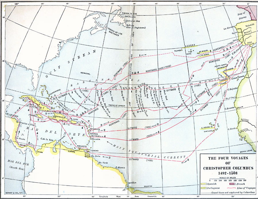
Description: A map of the North Atlantic showing the routes, directions, and dates of the four voyages of Columbus, from 1492 to 1503. This map is color-coded to show the territories in Africa, South America, and Atlantic islands claimed by the Portuguese, and territories in the West Indies, South America, and Atlantic islands claimed by the Spanish. The outward routes of the first and third voyages from Palos, and the second and fourth voyages from Cadiz are shown, as well as the routes in the West Indies and homeward routes. Points along the first outward voyage west of the Canary Islands are dates between September 6, 1492, and the sighting of land on October 12, 1492, and include notes from the ship's log indicating adjustments to the Westerly Variation, bird and flying fish sightings, sea weed, weather and sailing conditions (Sea as smooth as the River at Seville), and the full moon at 10:58 pm on October 5. This map shows the Demarcation Line of 1494 separating land claims in the New World between Spain and Portugal, and indicates the lands discovered in North America by others (Tierra de los Bretones, Tierra de los Bacalhos, and Cavo de Ynglaterra).
Place Names: Regional Atlantic Ocean, North America, �South America, �Africa, �Europ
ISO Topic Categories: physical, �historical, �transportation, �political, kWorldAtlantic, kWorldAmericas
Keywords: The Four Voyages of Columbus, physical, �historical, �transportation, �political, physical features, country borders, water routes, historical event, physical, �historical, �transportation, �political, kWorldAtlantic, kWorldAmericas, Unknown, 1492–1503
Source: Albert Bushnell Hart, LL.D., The American Nation Vol 3 (New York, NY: Harper and Brothers, 1906) 34
Map Credit: Courtesy the private collection of Roy Winkelman |
|