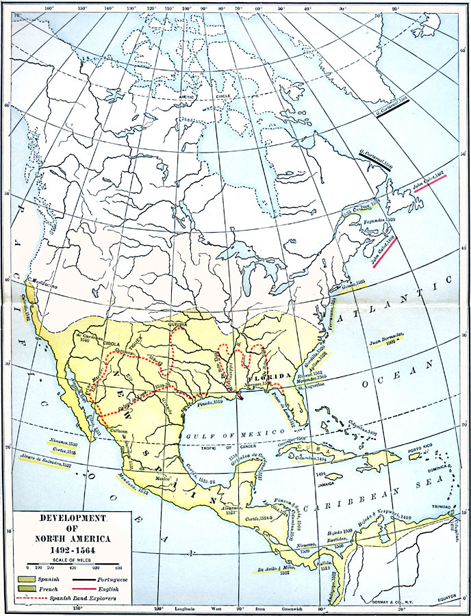
Description: A map of the Americas showing the European exploration and development between the first voyage of Christopher Columbus (1492) and the establishment of Saint Augustine, Florida by Pedro Menendez de Aviles (1564). The map is color–coded to show the territories claimed by Spain, and territory claimed by France in the Carolinas and northern Florida by Jean Ribault in 1562. The areas in North America explored by the Portuguese and British in this period are shown, with the name of the explorer and date given. The land routes of Spanish explorers are shown with a dashed red line. The map shows the explorations of Columbus (1492), Columbus (1494), John Cabot (1497–1498), Columbus (1498), Hojeda and Vespucci (1499), Bastidas (1500), Cortereal (1500–1501), Columbus (1502), Juan Bermudez (1502), Pinzon and Solis (1508), Ocampo (1508), Hojeda (1509), Nicuessa (1509), Ponce de Leon (1512), Balboa (1513), de Cordova (1517), Grijalva (1518), Pineda (1519), Cortez (1519–1522), Gordillo (1520), De Avila and Mino (1522), Andagoya (1522), Alvarado (1523), de Olid (1524), Cortez (1524–1525), Verrazano (1524), Gomez (1525), Ayllon (1526), Alvaro de Saavedra (1527), Narvaez (1528), Ximenes (1530), de Guzman (1531), Mendoza (1532), Cabeza de Vaca (1534–1536), Cartier (1534–1535), Cortez (1535), Friar Marcos (1539), Coronado (1540–1542), Alarcon (1540), de Cardenas (1540), Cabrillo (1542), De Soto (1548), Ulloa (1551), Ribaut (1562), and Menendez (1565).
Place Names: A Complete Map of North America, Canada, �Cuba, �Mexico, �United States, �Bahamas, �Jamaic
ISO Topic Categories: inlandWaters,
location,
oceans
Keywords: Development of North America, physical, physical features, inlandWaters,
location,
oceans, Unknown, 1492–1564
Source: Albert Bushnell Hart, LL.D., The American Nation Vol 3 (New York, NY: Harper and Brothers, 1906) 135
Map Credit: Courtesy the private collection of Roy Winkelman |
|