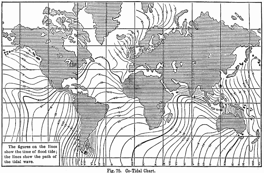
Description: A map from 1891, showing the progress of the daily lunar tidal wave in each of the oceans. "Although a tidal wave is formed in all parts of the ocean where the moon is overhead, yet the ‘Cradle of the Tides’ may properly be located in the great southern area of the Pacific Ocean. Here the combined attraction of the sun and moon originate a wave...The progress of the tidal wave, in each of its oceans, is best understood by tracing on a map, lines connecting all places which receive the tidal wave at the same time. These are called co-tidal lines. The distance between two consecutive lines represents the time, in hours, required for the progress of the tidal wave. In parts of the ocean where the wave travels rapidly the co-tidal lines are far apart; when its progress is retarded, they are crowded together. Twice every day starts in the south-eastern part of the Pacific Ocean, somewhere between the two heavy lines marked XII on the chart. It advances rapidly toward the north-west in the deep valley of this ocean, reaching Kamtchatka in about 6 hours. Toward the west its progress is retarded by the shallow water, and by the numerous islands, so that it only reaches New Zealand in about 6 hours and enters the Indian Ocean in about 12 hours. The 12-hour-old tidal wave from the Pacific, meets and moves along with a wave started in this ocean by the moon, and advances in the direction indicated by the co-tidal lines entering the Atlantic Ocean about 12 hours afterward. The tidal wave from the Indian joins two other waves, one formed by the moon in this ocean, and the other a deflected wave that has backed into the Atlantic from the Pacific. The tidal wave thus formed advances rapidly up the deep valley of the Atlantic, reaching Newfoundland 12 hours afterward, or 48 hours after it started in the Pacific." &mdash E. Houston, 1891, pp. 78-79.
Place Names: A Complete Map of Globes and Multi-continent, Earth,
ISO Topic Categories: climatologyMeteorologyAtmosphere
Keywords: Co-Tidal Chart, tidal, �water, �hydrological, kHydrologic, currents, climatologyMeteorologyAtmosphere, Unknown, 1891
Source: Edwin J. Houston, A. M. , The Elements of Physical Geography (Philadelphia, PA: Eldredge & Brother, 1891) 78
Map Credit: Courtesy the private collection of Roy Winkelman |
|