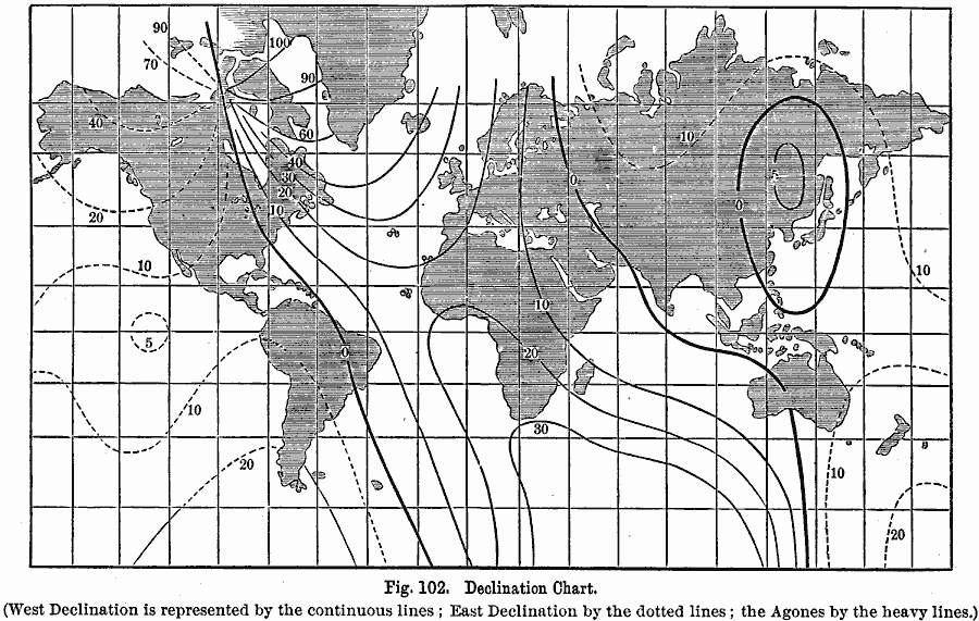
Description: A world chart from 1891showing the Earth's east-west declination of the magnetic poles from the geographic poles. "Lines connecting places which have the same declination, are called isogonal lines. Lines connecting these places, when the needle points to the true north, are called agones, or lines of no declination. The direction of the isogonal lines is shown on the declination chart, the figures near the lines giving the value of the declination in degrees. The agone in each hemisphere is marked 0. In the New World it enters South America near Rio Janeiro, curves to the eastward around the Antilles, passes near Washington, through the western part of Hudson Bay, and enters the magnetic pole at Boothia Felix. The agone, in the Old World, passes through the west of Australia, near the western coasts of Hindostan, through Persia, the eastern part of the Caspian Sea, and through the White Sea, in Europe. The oval curves in Eastern Asia seem to indicate a secondary magnetic pole. In nearly all of Europe, in the whole of Africa and Arabia, in eastern North and South America, and in nearly all of the Atlantic and Indian Oceans, the declination is west. It is also west along the eastern shores of Asia, around the secondary magnetic pole. In the remainder of the world the declination is east." — Houston, 1891, pp. 113-4.
Place Names: A Complete Map of Globes and Multi-continent, Africa, �Antarctica, �Asia, �Australia, �Europe, �North America, �South Americ
ISO Topic Categories: oceans,
location,
inlandWaters
Keywords: Declination Chart, declination, oceans,
location,
inlandWaters, Unknown, 1891
Source: Edwin J. Houston, A. M. , The Elements of Physical Geography (Philadelphia, PA: Eldredge & Brother, 1891) 113
Map Credit: Courtesy the private collection of Roy Winkelman |
|