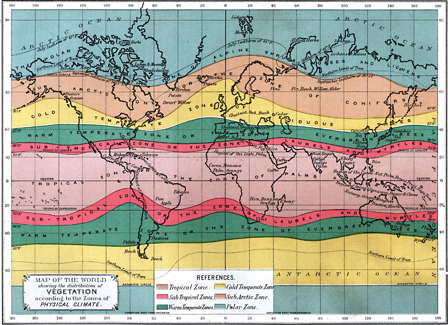
Description: A world map from 1891 showing the distribution of vegetation according to the zones of physical climate. This map is color-coded to show the Tropical Zone, Sub-Tropical Zones, Warm Temperate Zones, Cold Temperate Zones, Sub-Arctic Zone, and Polar Zones. These zones are defined by isotherms of mean temperature, with the tropical zone between temperatures above 73° F., sub-tropical zones between 73° and 68° F., warm temperate zones between 68° and 55° F., cold temperate zones between 55° and 41° F., the northern sub-arctic zone between 41° F. and the September isotherm of 36° F., and the polar zones below 36° Fahrenheit. The July isotherm of 41° F. is shown, along with the northern and southern limits of trees. The physical climate zones are also shown with their flora designations, including the Polar Zone or Zone of Alpine Shrubs, Mosses, and Lichens, the Sub-Arctic Zone or Zone of Conifers, the Cold Temperate Zone of Deciduous Trees, the Warm Temperate Zones or Zones of Evergreen Trees, Sub-Tropical Zones or Zones of Laurels and Myrtles, and the Tropical Zone or Zone of Palms and Bananas. Each zone shows representative vegetation and crops, and regions of cultivation.
Place Names: A Complete Map of Globes and Multi-continent, Africa, �Antarctica, �Asia, �Australia, �Europe, �North America, �South Americ
ISO Topic Categories: oceans,
location,
inlandWaters
Keywords: Map of the World showing the distribution of Vegetation according to the Zones of Physical Climate, climate, �meteorological, �temperature, �vegetation, kBiodiversity, kClimate, vegetation, climate,
temperature, oceans,
location,
inlandWaters, Unknown, 1891
Source: Edwin J. Houston, A. M. , The Elements of Physical Geography (Philadelphia, PA: Eldredge & Brother, 1891) 121
Map Credit: Courtesy the private collection of Roy Winkelman |
|
