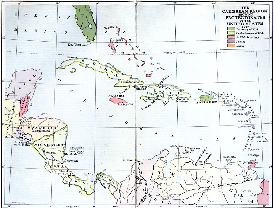
Description: A map of the Caribbean region showing the protectorates of the United States and territorial claims of the United States, Britain, France, and the Netherlands in 1917. The map is color–coded to show the U.S. territories in green (Porto Rico and the Panama Canal), British territories in pink (British Honduras or Belize, Bahama Islands, Jamaica, Trinidad, and other islands of the region), French territories in Purple (Guadeloupe, Martinique, and other islands of the region), and Dutch territories in orange (Oruba or Aruba, Buen Ayre or Bonaire, and Curaçao). The map shows the protectorates of the United States in the region outlined in green, including Cuba, Haiti, Dominican Republic, and Panama. The Central American countries of Costa Rica, Nicaragua, Honduras, Salvador, and portions of Guatemala, Mexico, Columbia, and Venezuela are also shown.
Place Names: Regional Americas, Cuba, �Mexico, �United States, �Canada, �Bahamas, �Puerto Rico, �Trinidad, �Tobago, �Honduras, �Nicaragua, �Costa Rica, �Panama, �Mexico, �Guatemala, �Columbia, �South America, �Central Americ
ISO Topic Categories: physical, �political, kWorldAmericas
Keywords: The Caribbean Region, physical, �political, physical features, country borders, physical, �political, kWorldAmericas, Unknown, 1917
Source: Albert Bushnell Hart, L.L.D., The American Nation Vol. 27 (New York, NY: Harper and Brothers, 1919) 248
Map Credit: Courtesy the private collection of Roy Winkelman |
|