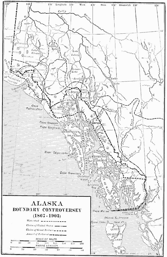
Description: A map of southeastern border of Alaska and Canada showing the area of boundary dispute and the boundary established by the Hay–Herbert Treaty between Britain and the United States in 1903. The map shows the coastline and fjords of the area, the gold rush jump–points of Juneau, Skaguay, Dyea, Klukwan, and Pyramid Harbor, the mountain passes to the gold fields, the city of Sitka, Fort Wrangel, and the disputed Portland Canal to the south. The dispute originated from the treaty between Russia and Britain in 1825, when the border was established as "ten marine leagues from the ocean." When the United States purchased the Alaska territory from Russia in 1867, Canada claimed the ten leagues to be from the mouth of the fjords, while the United States claimed it from the head of the fjords, thus increasing the territory substantially to the east. During the Klondike Gold Rush, the dispute came to focus due to control of the Chilkoot Pass and White Pass from the coast into the goldfields. In 1903, arbitration was set up to settle the dispute, with a tribunal of three Americans, two Canadians, and one British. The British sided with the Americans (Hay–Herbert Treaty), a compromise was settled on, and the border was established between the two claims, not to the full pleasure of the Canadians.
Place Names: Alaska, Skagway, �Junea
ISO Topic Categories: boundaries,
location,
inlandWaters,
oceans,
transportation
Keywords: Alaska Boundary Controversy, physical, �political, �transportation, physical features, country borders,
major political subdivisions, railroads, boundaries,
location,
inlandWaters,
oceans,
transportation, Unknown, 1867–1903
Source: Albert Bushnell Hart, LL.D., The American Nation Vol. 25 (New York, NY: Harper and Brothers, 1907) 200
Map Credit: Courtesy the private collection of Roy Winkelman |
|