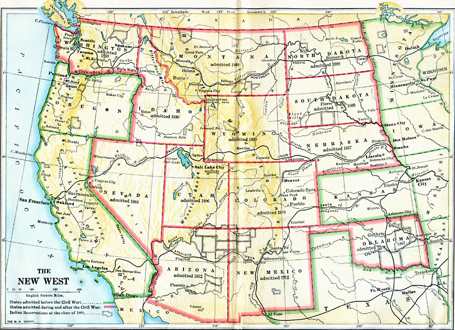
Description: A map of the western United States showing the rapid growth of the New West between 1885 and 1912 during the presidencies from Benjamin Harrison to Howard Taft. The map is color–coded to show the States admitted to the Union before the American Civil War and after, with dates admitted given. The map shows State capitals and major cities, railroads, Indian reservations, and rivers. "One of the first things to engage the attention of the Harrison administration was the organization of new States in the Far West. It fell to the lot of President Harrison to proclaim the admission of more new States than were ever admitted during the administration of any other President. The rapid development of the Western country was due chiefly to the influence of the transcontinental railroads which were completed in the early eighties." — Forman, 1919, pp. 530–531.
Place Names: Growth of Nation, Arkansas, �California, �Colorado, �Minnesota, �Missouri, �Nevada, �New Mexico, �North Dakota, �Oklahoma, �Oregon, �South Dakota, �Texas, �United States, �Utah, �Virginia, �West Virginia, �Wisconsin, �New Wes
ISO Topic Categories: oceans,
location,
inlandWaters,
boundaries
Keywords: The New West, borders, �historical, �land, �physical, kNativeAmerican, physical features, ethnological, historical event, oceans,
location,
inlandWaters,
boundaries, Unknown, 1889–1912
Source: S.E. Forman, Advanced American History (New York, NY: The Century Company, 1919)
Map Credit: Courtesy the private collection of Roy Winkelman |
|