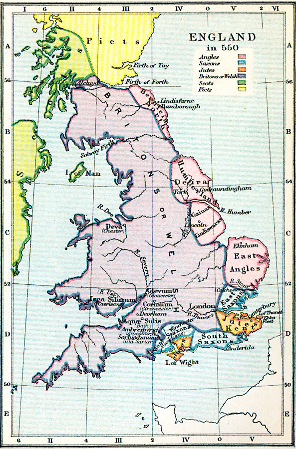
Description: A map of England and Wales in AD 550, after the departure of the Romans (AD 410) and during the migration of the Angles, Saxons, and Jutes from Europe. The map is color–coded to show the territories of the native Britons or Welsh, Angles, Saxons, Jutes, and the Scots and Picts to the north. The map shows the major settlements, rivers, and coastal features, and indicates Roman settlements with the modern names in parentheses, including Deva (Chester), Isca Silurum (Caerleon), Glevum (Gloucester), Corinium (Cirencester), Aquæ Sulis (Bath), Ambresbyria (Amesbury), and Sorbiodunum (Old Sarum). The Roman barriers of the Antonine and Hadrian's walls against the Picts are shown.
Place Names: United Kingdom, London, �Isca Silurum, Glevum, Corinium, Deorham, Aquae Sulis, Ambresbyric, Kent, Thames River, Deva, Isle of Man, Firth of Fort
ISO Topic Categories: inlandWaters,
oceans,
society,
boundaries,
location
Keywords: England, physical, �statistical, �political, �england in 550, britons or welsh, east angles, jutes, south saxons, picts, scots, physical features, country borders, ethnological, inlandWaters,
oceans,
society,
boundaries,
location, Unknown, AD 550
Source: Samuel Rawson Gardiner D.C.L., L.L.D., School Atlas of English History (London, England: Longmans, Green, and Co., 1914) 3
Map Credit: Courtesy the private collection of Roy Winkelman |
|