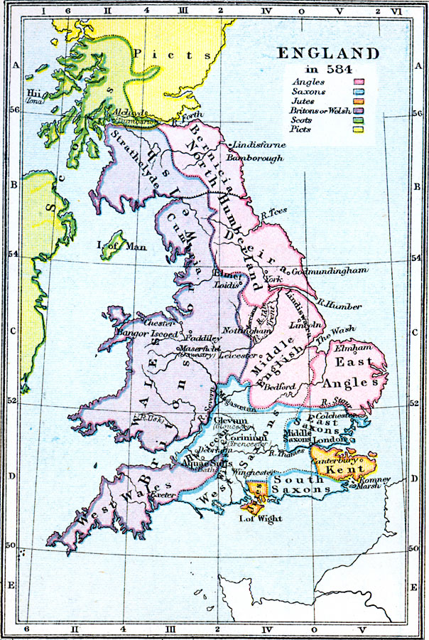
Description: A map of England and Wales in AD 584 at the end of the conquest of the Britons by West Saxons under Ceawlin and Cutha. The map is color–coded to show the territories of the native Britons or Welsh, Angles, Saxons, Jutes, and the Scots and Picts to the north. The map shows the major settlements, rivers, and coastal features, and indicates Roman settlements with the modern names in parentheses, including Deva (Chester), Isca Silurum (Caerleon), Glevum (Gloucester), Corinium (Cirencester), Aquæ Sulis (Bath), Ambresbyria (Amesbury), and Sorbiodunum (Old Sarum). After taking the cities of Glenvum, Corinium, and Aquæ Sulis, the West Saxons moved northward with the goal of reaching Chester, however they were defeated at Faddiley by the Britons, who slew Cutha in the battle.
Place Names: United Kingdom, London, �Isca Silurum, Glevum, Corinium, Deorham, Aquae Sulis, Ambresbyric, Kent, Thames River, Deva, Isle of Man, Firth of Forth, Exeter, Nottingham, Lincoln, Yor
ISO Topic Categories: inlandWaters,
oceans,
society,
boundaries,
location
Keywords: England, physical, �statistical, �political, �england, britons or welsh, east angles, jutes, south saxons, picts, scots, middle english, physical features, country borders, ethnological, inlandWaters,
oceans,
society,
boundaries,
location, Unknown, AD 584
Source: Samuel Rawson Gardiner D.C.L., L.L.D., School Atlas of English History (London, England: Longmans, Green, and Co., 1914) 4
Map Credit: Courtesy the private collection of Roy Winkelman |
|