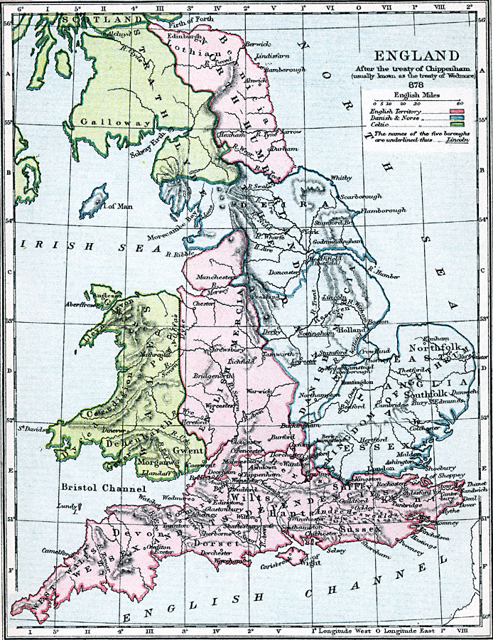
Description: A map of England, Wales, and southern Scotland in AD 878 after the Treaty of Chippenham (also known as the Treaty of Wedmore) between King &Aelig;lfred of the Anglo–Saxons and the Danish King Guthrum, which ended this period of Viking invasion of England. The map is color–coded to show the territories of the native Celts in Wales, Scotland, and the northern portion of Strathclyde, the territories of the English under &Aelig;lfred in central and southern England, and the territories of the Danes and Norse in the east (Danelaw). The names of the ‘Five Boroughs&rlquo; (Derby, Leicester, Lincoln, Stamford, and Nottingham), the main towns under Danelaw, are indicated by underlining.
Place Names: United Kingdom, London, �Worcester, �Warwick, �River Avon, �Bristol, �Nottingham, �Scarborough, �Flamborough, �Solway Firth, �Edinburgh, �Edinborough,
ISO Topic Categories: boundaries,
inlandWaters,
location,
oceans,
society
Keywords: England After the Treaty of Chippenham, physical, �political, �statistical, �england after treaty of chippenham aka treaty of wedmore 878 CE, kingdom of guthrum, essex, east anglia, wessex and its dependencies, wales, english mercia, north humberland, strathclyde, physical features,
topographical, country borders,
major political subdivisions, ethnological, boundaries,
inlandWaters,
location,
oceans,
society, Unknown, AD 878
Source: Samuel Rawson Gardiner D.C.L., L.L.D., School Atlas of English History (London, England: Longmans, Green, and Co., 1914) 7
Map Credit: Courtesy the private collection of Roy Winkelman |
|
