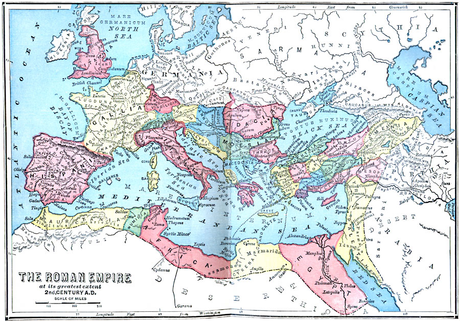
Description: A map of the Roman Empire at its great extent, in the second century A.D., the century known as the period of the "Five Good Emperors" (Nerva, Trajan, Hadrian, Antonius Pius, and Marcus Aurelius). The map shows the boundaries of the empire as established by Augustus, provinces, major cities, roads, rivers, mountain systems, coastal features, and islands within the empire. "The entire Empire, exclusive of Italy, was divided into 27 ‘Provinces,’ which may be conveniently grouped under three heads: 1. The Western, or European; 2. The Eastern, or Asiatic; 3. The Southern, or African. The Western Provinces numbered 14; the Eastern 8; the Southern 5." — Swinton, 1874, p. 183.
Place Names: Regional Mediterranean, Africa, �Europe, �Asi
ISO Topic Categories: physical, �transportation, �political, kRomanEmpire, kWorldMedSea, kWorldAfroAsia, kWorldEurasia, kWorldEuroAfrica
Keywords: Roman Empire, physical, �transportation, �political, kRomanEmpire, physical features, major political subdivisions, roads, physical, �transportation, �political, kRomanEmpire, kWorldMedSea, kWorldAfroAsia, kWorldEurasia, kWorldEuroAfrica, AD 101–200
Source: William Swinton, Outlines of the World's History (New York, NY: Ivison, Blakeman, and Company, 1874) 183
Map Credit: Courtesy the private collection of Roy Winkelman |
|