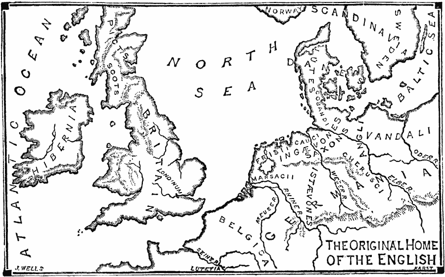
Description: A map of the British Isles and north central Europe around the time the Romans left Britannia (AD 410), and the original homelands of the English. The map shows the territories of Hibernia (Ireland), Britannia, Belgica, Germania, Scandinavia, and the territories of the Picts, Scots, Danes, Jutes, Frisii, Cauci, Ingævones, Saxons, Angli, Vandali, Marsacii, Istævons, and Cheruci. "The Roman troops had been withdrawn from the province of Britain about a half century before the downfall of Rome, and the Britons, who belonged to the Celtic race, were left to shift for themselves. About the middle of the 5th century various Teutonic tribes belonging to the Low–German stock, and coming from the Low–German lands by the Elbe and the Weser, invaded Britain and won for themselves new homes there. They knew nothing and cared nothing for the language or arts of Rome, and they did not, like the Franks and Goths, adopt the language and religion of the Romans. These swept everything before them, and the native Celtic Britons were killed, enslaved, or driven to the mountain regions of Wales and North Britain. Among these Low–German invaders were three main tribes, — the Angles, Saxons, and Jutes. The name Jute has left no memorial in England; but the English people are still often spoken of as belonging to the Saxon race, while the speech which arose in the island from the intermixture of the various German dialects took the name of Anglo–Saxon, and Britain changed its name to England, or the land of the Angles." — Swinton, 1874, pp. 225–226.
Place Names: Western and Central Europe, United Kingdom, �Franc
ISO Topic Categories: boundaries,
location,
oceans,
inlandWaters
Keywords: Original Home of the English, physical, kRomanEmpire, physical features, boundaries,
location,
oceans,
inlandWaters, AD 400
Source: William Swinton, Outlines of the World's History (New York, NY: Ivison, Blakeman, and Company, 1874) 226
Map Credit: Courtesy the private collection of Roy Winkelman |
|