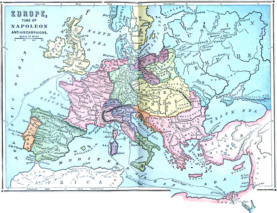
Description: A map of Europe at the time of Napoleon and his campaigns (1796–1815), showing the political boundaries at the time, and the routes of The First Italian Campaign with the battle sites of Lodi and Arcole, and the Treaty of Campo Formio (1796), The Egyptian Expedition (1798-1799), which included the capture of Malta (1798), the Battle of the Pyramids, Battle of the Nile (naval battle at Aboukir, lost to Horatio Nelson), the Syrian Campaign (1799), and return to Paris, installed himself as First Consul (1799), The Second Italian Campaign and the Battle of Marengo (War of the Second Coalition, 1800), became Emperor of France (1804), War of the Third Coalition (1803-1805), including Bouloone (Boulogne-sur-Mer, 1804-1805), the Ulm Campaign (1805), Britain's victory at the Battle of Trafalgar, Napoleon's victory at the Battle of Austerlitz, the War of the Fourth Coalition (1806-1807), including the Battle of Jena (1806), Battle of Friedland (1807) and the Treaty of Tilsit, the War of the Fifth Coalition (1809), including the Battle of Ratisbon (Regensburg), and Battle of Wagram (1809), the invasion of Russia (1812), including the Battle of Smolensk and the Battle of Borodino, and retreat from Moscow, the War of the Sixth Coalition (1812-1814), including Napoleon's defeat at the Battle of Leipzig, his surrender and abdication under the Treaty of Fontainebleau and exile to the Mediterranean island of Elbe (1814), his return to Paris for his Hundred Days rule, the Battle of Waterloo, final surrender at Rochefort (Roquefort), and exile to St. Helena (1815).
Place Names: A Complete Map of Europe, France, �Spain, �Portugal, �Prussia, �Grand Duchy of Warsaw, �Ottoman Empir
ISO Topic Categories: boundaries,
location,
inlandWaters,
oceans,
intelligenceMilitary
Keywords: Europe During Napoleon's Campaigns, physical, �political, �transportation, kNapoleonBonaparte, physical features, country borders, water routes, boundaries,
location,
inlandWaters,
oceans,
intelligenceMilitary, 1796–1815
Source: William Swinton, Outlines of the World's History (New York, NY: Ivison, Blakeman, and Company, 1874) 441
Map Credit: Courtesy the private collection of Roy Winkelman |
|