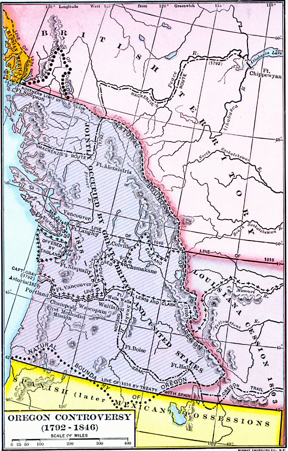
Description: A map of the Oregon Territory between the time of exploration by George Vancouver (1792) and the Oregon Treaty of 1846. The map is color–coded to show the disputed claims of the British and United States, the Russian American line of 1825, the territory of the Louisiana cession of 1803, the British and United States boundary to the east of the territory established in 1818, the proposed boundary by the British to the Columbia River and offer of the Olympic Peninsula, the Spanish (later Mexico) possession to the south established in 1819, and the boundary between British territory and the United States established by the Oregon Treaty. The map shows the natural boundary of the Oregon Country based on the watershed divide of the Rockies, and the exploration routes of Capitan Gray (1792), Mackenzie (1792), Lewis and Clark (1805), and the western portion of the Oregon Trail.
Place Names: Growth of Nation, British Territory, �Louisiana Cession, �Oregon, ��Original Colonies, �Oregon Countr
ISO Topic Categories: oceans,
location,
inlandWaters,
boundaries
Keywords: Oregon Controversy, borders, �historical, �political, country borders, historical event, oceans,
location,
inlandWaters,
boundaries, Unknown, 1792–1846
Source: Dixon Ryan Fox, Harper's Atlas of American History (New York, NY: Harper & Brothers Publishers , 1920) 43
Map Credit: Courtesy the private collection of Roy Winkelman |
|