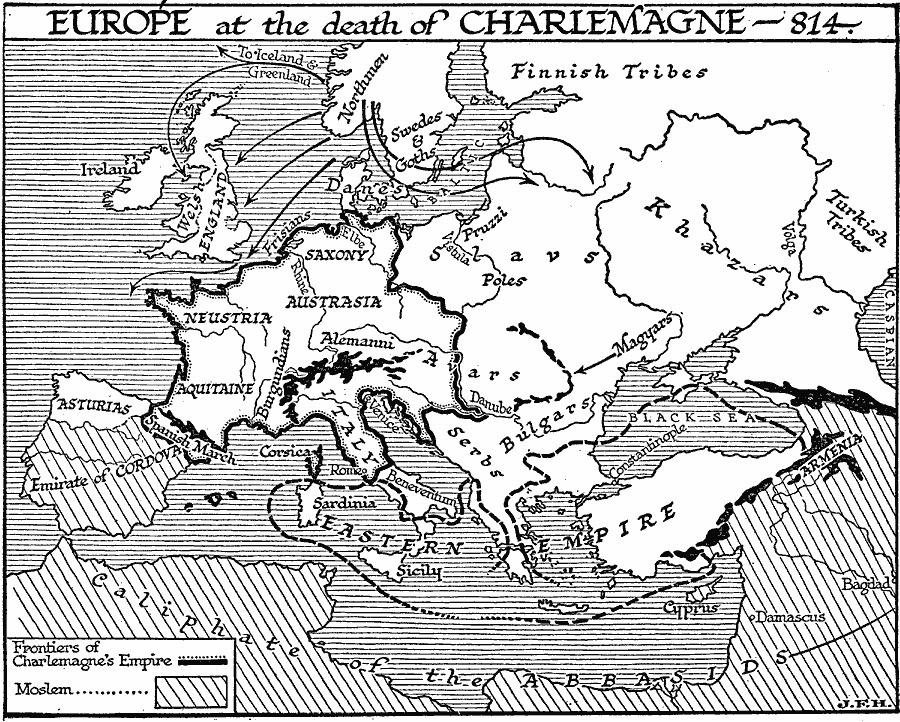
Description: A map of Europe in AD 814, at the death of Charlemagne, showing the frontiers of Charlemagne's Empire, which included Neustria, Saxony, Austrasia, Aquitaine, Spanish March (or Marca Hispanica, the buffer zone created by Charlemagne in AD 795 between the Frankish Empire and the Umayyad Moors of the Iberian Peninsula), Italy, the territories of the Burgundians and Alemanni, and portions of the Avars territory. This map shows the extent of the Eastern or Byzantine Empire, and the Moslem territories of the Caliphate of the Abbasids, and Emirate of Cordova. The map also shows the expansion routes of the Northmen (Norse) to Iceland and Greenland, the British Isles, and Slav territories, and shows the territories of the Asturians, Finnish tribes, Swedes and Goths, Slavs, Khazars, Pruzzi, Poles, Magyars, Bulgars, and Serbs.
Place Names: Western and Central Europe, Cordova, �Italy, �Engalnd, �Eastern Empire, Neustria, Saxony, Austrasia, Aquitaine, Spanish March, Caliphate of the Abbasids
ISO Topic Categories: boundaries,
location,
oceans,
inlandWaters
Keywords: Europe at the Time of Charlemagne, physical, �political, kCharlemagne, physical features, major political subdivisions, boundaries,
location,
oceans,
inlandWaters, Unknown, A.D. 814
Source: H. G. Wells, The Outline of History (New York, NY: The Macmillan Company, 1921) 620
Map Credit: Courtesy the private collection of Roy Winkelman |
|