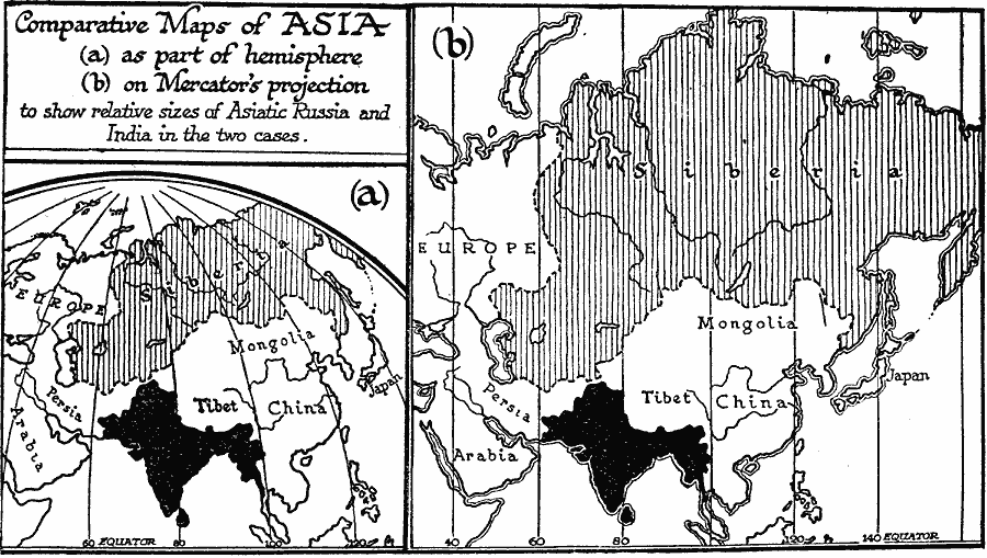
Description: A map using comparative map projections of Asia, as part of a hemisphere and on a Mercator's projection, to illustrate European misconceptions of land claims during territorial colonialism. In the 19th century, European powers were extending their empires across Asia, including Russia and Great Britain as shown on this map. On a hemispherical projection, India appears larger and Siberia appears smaller than they do on a Mercator's projection. For this reason, the implied significance, and imagined superiority of land claims depended on the projection used. "We look to-day at the maps of Europe since 1814, we compare them with the natural map, and we see that the game the Great Powers played was indeed a game of foregone conclusions. Whatever arrangements they made that were in accordance with the natural political map of the world, and the trend towards educational democracy, held, and whatever arrangements they made contrary to these things, collapsed. We are forced, therefore, to the conclusion that all the diplomatic fussing, posturing, and scheming, all the intrigue and bloodshed of these years, all the monstrous turmoil and waste of kings and armies, all the wonderful attitudes, deeds, and schemes of the Cavours, Bismarcks, Disraelis, Bonapartes, and the like "great men," might very well have been avoided altogether had Europe but had the sense to instruct a small body of ordinarily honest ethnologists, geographers, and sociologists to draw out its proper boundaries and prescribe suitable forms of government in a reasonable manner." — Wells, 1921, p. 975.
Place Names: A Complete Map of Asia, China, �India, �Tibet, �Japan, �Mongolia, �Siberi
ISO Topic Categories: boundaries,
location,
oceans,
inlandWaters
Keywords: Comparative Projections of Asia, physical, �political, kMapProjection, physical features, country borders, boundaries,
location,
oceans,
inlandWaters, Mercator, 1800–1899
Source: H. G. Wells, The Outline of History (New York, NY: The Macmillan Company, 1921) 976
Map Credit: Courtesy the private collection of Roy Winkelman |
|