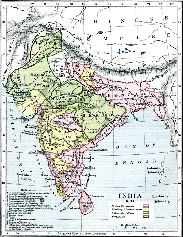
Description: A map of British India in 1804, at the end of the Second Anglo–Maratha War (1803–1804). The map is color–coded to show the British dominions, the subsidiary and protected states, the independent states at the time, and the Portuguese possessions of Goa and Diu Island. Map references show the ancient British possessions or those of the East India Company (1), countries ceded to Britain in the Mysore between 1792–1799 (2), countries ceded in the Carnatic in 1802 (3), countries ceded in Oudh in 1801 (4), countries ceded in Gujerat in 1801 (5), conquered countries in the Anglo–Maratha War in 1803 (6), powers under the protection of the East India Company (7), Mahratta States which in consequence of the late transactions subsidized troops of the East India Company (8), the Mahratta State of Sindhia (9), the Mahratta State of Holkar (9+), the Mahratta State of Berar (10), the Rapoot States (11), Sikhs (12), the independent states of Cutch (13) and Sindh (14), the Jagheir of Rampore (15), the Jagheirs of Samroo Beagum (16), and the Bundelcund understood to be exchanged by the Peishwah for territories first ceded by him on the western coast (17).
Place Names: India , Zurich, �Luzern, �Milan, �Turin, �Pavia, �Garda, �Modena, �Bologna, �Parma, �Leghorn, �Venice, �Manuta, �Italy, �Switzerlan
ISO Topic Categories: inlandWaters,
location,
boundaries,
oceans
Keywords: India after the Second Anglo–Maratha War, physical, �political, �map of india in 1804, british dominions, subsidiary and protected states, independent states, portuguese, mahratta states, jagheirs, physical features,
topographical, country borders,
major political subdivisions, inlandWaters,
location,
boundaries,
oceans, Unknown, 1804
Source: Samuel Rawson Gardiner D.C.L., L.L.D., School Atlas of English History (London, England: Longmans, Green, and Co., 1914) 54
Map Credit: Courtesy the private collection of Roy Winkelman |
|
