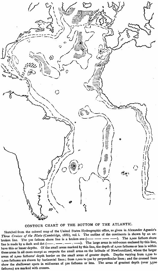
Description: A sketch from a map of the 1888 United States Hydrologic office, showing the Atlantic Basin, outline of the continents, 500 fathom submerged shoreline, and 2,000 fathom submerged shoreline. Depths varying from 1,000 fathoms to 1,000 fathoms are shown by horizontal lines, from 1,000 to 500 fathoms by perpendicular lines, and the crossed lines show the shallowest spots in mid–ocean of 500 fathoms or less. The areas of greatest depth (over 3,500 fathoms) are marked with crosses.
Place Names: Regional Atlantic Ocean, Africa, �Europe, �North America, �South Americ
ISO Topic Categories: physical, hydrological, kWorldAtlantic
Keywords: Contour Chart of the Bottom of the Atlantic, physical, �hydrological, physical features, water depths, physical, hydrological, kWorldAtlantic, Unknown, 1888
Source: Justin Winsor, Narrative and Critical History of America Vol 1 (New York, NY: Houghton, Mifflin, and Company, 1889) 20
Map Credit: Courtesy the private collection of Roy Winkelman |
|