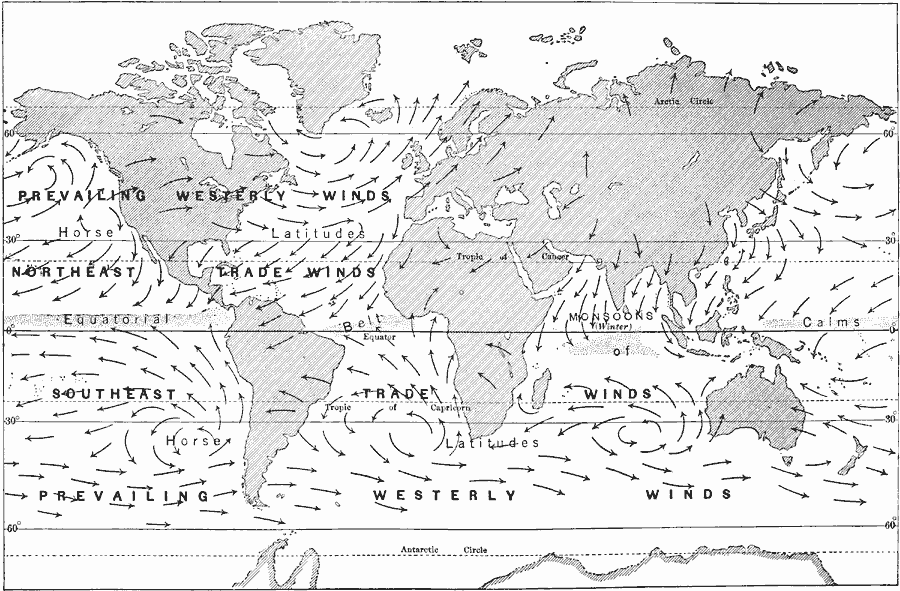
Description: A map of the world from 1916, showing prevailing Westerlies and Trade Wind systems. "Since the earth's surface is warmer in the equatorial regions than it is in the temperate or polar regions, the air is expanded and its upper parts flow off to the north and south towards the poles. At the same time the cooler air at the surface of the earth at the north and south of the equatorial calm belt moves in and forces the warm air to higher levels. This is the cause of the trade winds. [...] If the air should continue to move toward the Equator without any return currents, all the air would soon be piled up in one belt around the globe. But the air that moves upward in the belt of calms turns to the north and south and flows back over the trade winds. These upper currents are the anti-trade winds. [...] When the air of the anti-trades reaches the north and south limits of the trades, it descends to the earth in calm belts, known as the horse latitudes. These lie between 30° and 35° north latitude and between 30° and 35° south latitude. Some of the descending air supplies the trade winds and goes back to the Equator; some of it moves to the northeast in the Northern Hemisphere and to the southeast in the Southern Hemisphere, and forms, in both Temperate Zones, the prevailing westerly winds. While the trade winds turn toward the west, the winds of the Temperate Zones turn aside toward the east on account of the rotation of the earth. Thus the great winds keep up a circulation of the atmosphere between low and high latitudes and between the lands and the oceans." — Brigham and McFarlane, 1916, p. 259.
Place Names: A Complete Map of Globes and Multi-continent, Africa, �Antarctica, �Australia, �Asia, �Europe, �North America, �South Americ
ISO Topic Categories: climatologyMeteorologyAtmosphere,
location,
oceans
Keywords: Prevailing Westerlies and Trade Winds, meteorological, �physical, kClimate, kHydrologic, physical features, winds, climatologyMeteorologyAtmosphere,
location,
oceans, Unknown, 1916
Source: Albert Perry Brigham & Charles T. McFarlane, Essentials of Geography (New York, NY: American Book Company, 1916) 18
Map Credit: Courtesy the private collection of Roy Winkelman |
|