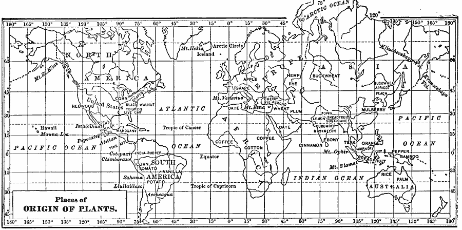
Description: A world map from 1899 showing the places of agricultural plant origins and places of cultivation. Specific plant origins include corn, redwood, tomato, potato, vanilla, coffee, cotton, grape, apple, wheat, hemp, rye, plum, date, buckwheat, ebony, teak, mulberry, cinnamon, orange, pepper, bamboo, breadfruit, rice, and palm, and areas of cultivation for black walnut, tobacco, live oak, mahogany, pineapple, India rubber, cherry, fig, almond, apricot, peach, poppy, lemon, sugarcane, cucumber, muskmelon, and camphor. Areas of plant origin are shown in large caps, areas of cultivation in smaller caps. The names of several prominent volcanoes are shown in italics.
Place Names: A Complete Map of Globes and Multi-continent, Africa, �Antarctica, �Asia, �Australia, �Europe, �North America, �South Americ
ISO Topic Categories: location,
oceans,
inlandWaters
Keywords: Places of Origins and Cultivation of Plants, statistical, �vegetation, kAgriculture, physical features, vegetation, location,
oceans,
inlandWaters, Unknown, 1899
Source: Horace S. Tarbell, LL.D. , The Complete Geography (New York, NY: American Book Company, 1899) 139
Map Credit: Courtesy the private collection of Roy Winkelman |
|