mapsMaps ETC Site map
 Maps ETC > Globes and Multi-continent > A Complete Map of Globes and Multi-continent > Steamship and Telegraph Routes Between the Grand Divisions of the World, 1888
Site Map 

Steamship and Telegraph Routes Between the Grand Divisions of the World, 1888

Steamship and Telegraph Routes Between the Grand Divisions of the World


Title: Steamship and Telegraph Routes Between the Grand Divisions of the World
Projection: Unknown,
Source Bounding Coordinates:
W: 20 E: 20 N: 80 S: -60

Main Map Page
Zoomify Version
B/W PDF Version
Color PDF Version
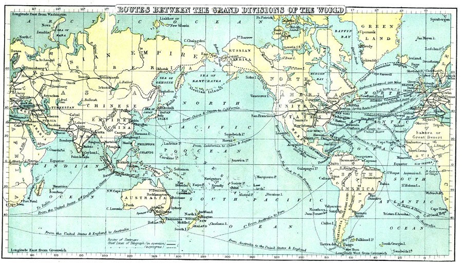
Description: A world map from 1888 showing principal steamship routes, telegraph (operational and proposed), and submarine telegraph cable routes at the time.
Place Names: A Complete Map of Globes and Multi-continent, Asia, Africa, Australia, North America, South America, Europ
ISO Topic Categories: inlandWaters, location, oceans, transportation
Keywords: Steamship and Telegraph Routes Between the Grand Divisions of the World, physical, political, transportation, physical features, railroads, water routes, inlandWaters, location, oceans, transportation, Unknown, 1888
Source: , Cornell's Intermediate Geography (New York, New York: American Book Company, 1888) 63
Map Credit: Courtesy the private collection of Roy Winkelman
SearchLicensePDF HelpGIS Help Google Earth Help Zoomify Help

 Maps ETC > Globes and Multi-continent > A Complete Map of Globes and Multi-continent > Steamship and Telegraph Routes Between the Grand Divisions of the World, 1888
Site Map