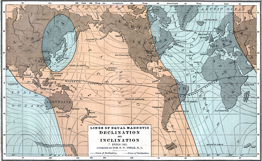
Description: A world map from 1885 showing the Earth's east–west declination of the magnetic poles from the geographic poles for the Epoch 1882. This map shows lines of declination (solid), lines of inclination, or dip of the compass needle from vertical (dashed), and the magnetic equator. "The buff color indicates easterly declination, the blue westerly. The lines which diverge from the magnetic poles have numbers affixed to them which show the amount of declination. A curious oval is observed upon the buff space. It embraces part of China and the Japanese Islands. Within its limits the declination is abnormal. It is westerly. From this it is inferred that there probably exists another, though subordinate, north magnetic pole in Northern Asia." — Maury, 1885, p. 13.
Place Names: A Complete Map of Globes and Multi-continent, Asia, �Australia, �North America, �South America, �Greenland, �Africa, �Europe, �Japa
ISO Topic Categories: inlandWaters,
location,
oceans
Keywords: Magnetic Declination and Inclination, physical, physical features, inlandWaters,
location,
oceans, Unknown, 1885
Source: M. F. Maury, Physical Geography (New York, New York: University Publishing Company, 1885) 12
Map Credit: Courtesy the private collection of Roy Winkelman |
|