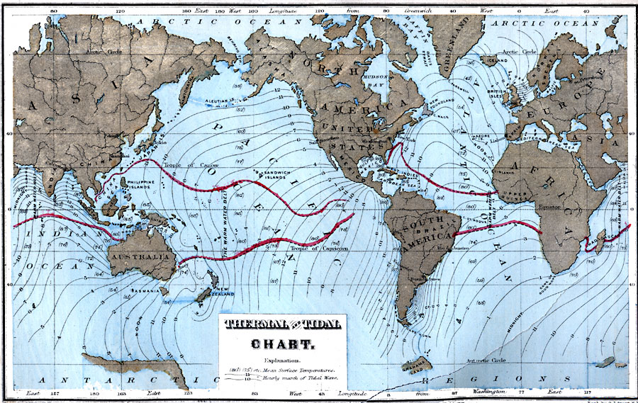
Description: A map of the world from 1873 showing ocean tides and temperature ranges. The map shows mean surface temperatures in parentheses, given in degrees Fahrenheit, and indicates the boundaries of the Warm Water Belt where surface waters have a mean temperature over 80° Fahrenheit. The map also gives co-tidal lines showing the progress of the daily lunar tidal wave in each of the oceans. "These lines connect places which have high tide at the same time. They represent the crest of the tidal-wave. In the waters about New Zealand, the birth-place of the tides, and to the northward as far as the Tropic of Cancer, they show that the tidal-wave extends nearly north and south. As it advances, portions of it are retarded, or deflected or even repelled by reefs, islands, or continental shores. The deeper the water, the more rapid is the rate of the tidal-wave. This is indicated by the bulging of the co-tidal lines. The distance of any two lines is the distance traversed in an hour." — Maury, 1873, p. 57.
Place Names: A Complete Map of Globes and Multi-continent, Asia, �Australia, �New Zealand, �North America, �United States, �South America, �Greenland, �Europe, �Afric
ISO Topic Categories: inlandWaters,
location,
oceans
Keywords: Thermal and Tidal Chart, physical, �political, �hydrological, physical features, currents,
water depths, inlandWaters,
location,
oceans, Unknown, 1873
Source: M. F. Maury, Physical Geography (New York, New York: University Publishing Company, 1885) 59
Map Credit: Courtesy the private collection of Roy Winkelman |
|