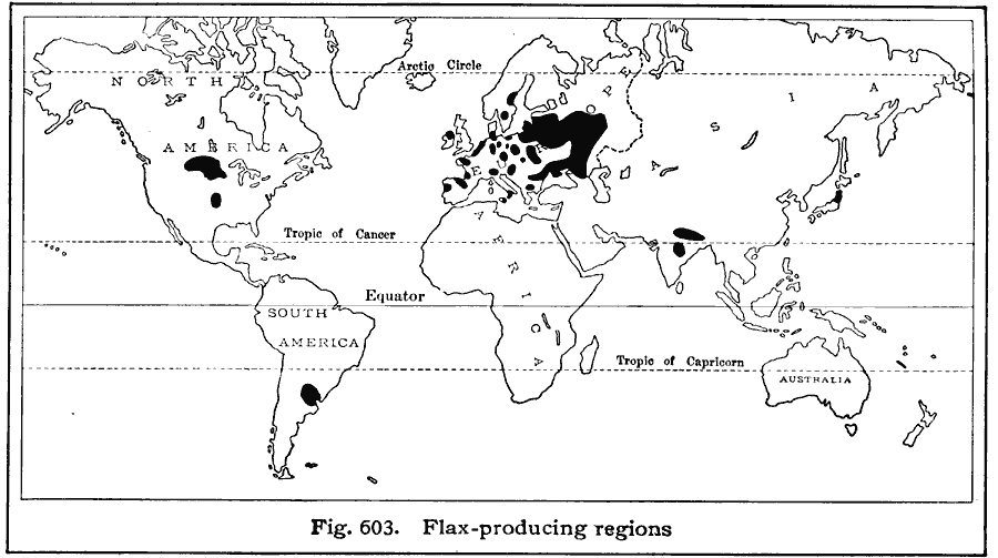
Description: A world map from 1916 showing the principal flax–producing regions of the world at the time. "Flax (fiber). World production, about 1,400,000,000 pounds a year. Reliable statistics are not now available. Before the World War, about 80% of the worldŐs flax fiber was grown in European Russia, and 7% in Austria–Hungary. France, Belgium, Ireland, and Netherlands each produce a small part of the worldŐs crop. Flaxseed (Five–year averages). WorldŐs annual production, 110,000,000 bushels. Countries leading in the production of flaxseed, with percentages of world production: Argentina (32%), India (18%), Russia (about 15%), United States (13%), Canada (9%). Average production of flaxseed in United States, 13,800,000 bushels. Leading flax–growing states, with percentages of United States production: North Dakota (47%), Minnesota (20%), Montana (17%), South Dakota (11%).
Place Names: A Complete Map of Globes and Multi-continent, Africa, �Antarctica, �Asia, �Australia, �Europe, �North America, �South Americ
ISO Topic Categories: farming,
location,
oceans
Keywords: Flax Producing Regions of the World, statistical, kAgriculture, agriculture, farming,
location,
oceans, Unknown, 1916
Source: Albert Perry Brigham & Charles T. McFarlane, Essentials of Geography (New York, NY: American Book Company, 1916) 408
Map Credit: Courtesy the private collection of Roy Winkelman |
|