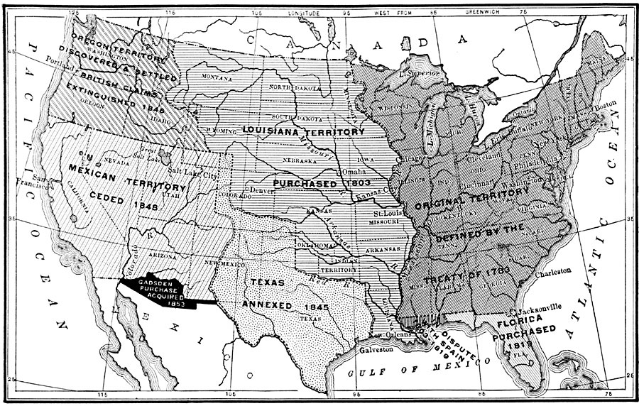
Description: A map from 1904 of the United States showing the territorial acquisitions up to the Gadsden Purchase in northern Mexico in 1853. The map is coded to show the territory of the original United States and the Northwest Territory defined by the Treaty of 1783, the Louisiana Purchase (1803), Florida purchased from Spain in 1819, the annexation of Texas in 1845, the Oregon Country in 1846, the Mexican cession of western lands in 1848, and the Gadsden Purchase in 1853.
Place Names: Growth of Nation, Oregon Country, �Louisiana Purchase, �Original Colonies, �West Florida, �Texas, �Gadsden Purchase, �Mexican Cession, �First Mexican Cession, �East Florida, �Californi
ISO Topic Categories: boundaries,
oceans,
location,
inlandWaters
Keywords: Expansion of the United States, physical, �political, physical features, country borders,
major political subdivisions, boundaries,
oceans,
location,
inlandWaters, Unknown, 1783–1853
Source: John Fiske, How the United States Became a Nation (Boston, MA: Ginn & Company , 1904) 4
Map Credit: Courtesy the private collection of Roy Winkelman |
|