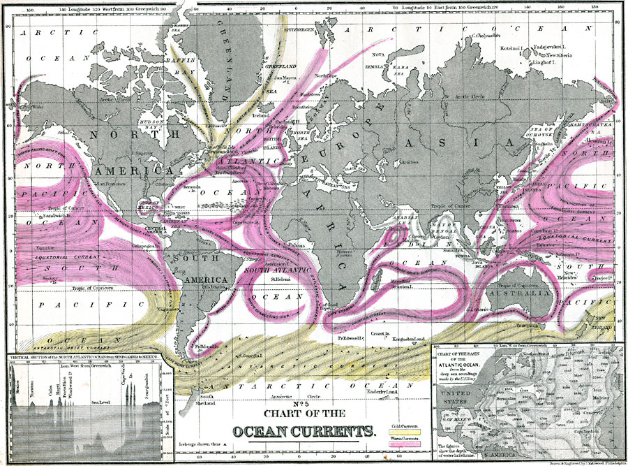
Description: A map of the world from 1890 charting the Ocean currents and chart of the basin of the Atlantic Ocean. This map is color–coded to show the directions of the warm and cold currents, including the Gulf Stream and branches, Guiana, North Africa and Guinea, Equatorial, South Atlantic, Brazil, La Plata, Cape, Mozambique, Trade Drift, Southern Counter, Japan, Kamtschatka, Australian, North Pacific Drift, Behring, California and Mexico Coast, and Humbolt currents (warm), and the Hudson Bay, Arctic, Cape Horn, and Antarctic Drift currents (cold). The map includes a vertical cross–section insert of the North Atlantic Ocean from Senegambia to Mexico at a scale in feet from 11,000 feet above to 16,500 feet below sea level, and an inset of the Atlantic Basin showing depths of water in fathoms from the deep sea soundings made by the U. S. Navy.
Place Names: A Complete Map of Globes and Multi-continent, Africa, �Antarctica, �Australia, �North America, �Europe, �South America, �Asia, �Greenlan
ISO Topic Categories: location,
oceans,
inlandWaters
Keywords: Chart of Ocean Currents, physical, �hydrological, physical features, water depths,
currents, location,
oceans,
inlandWaters, Unknown, 1890
Source: John Brocklesby, Elements of Physical Geography (Philadelphia, Pennsylvania: E. H. Butler and Co., 1890) 87
Map Credit: Courtesy the private collection of Roy Winkelman |
|