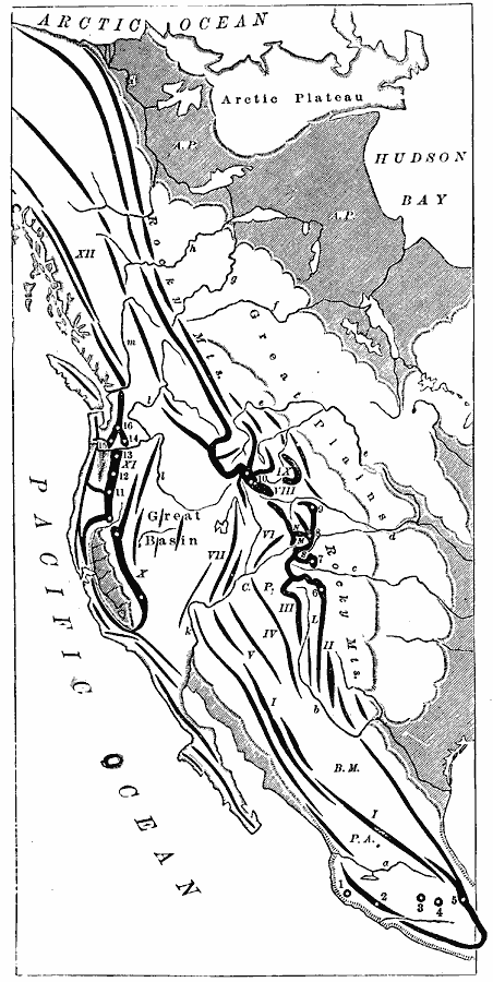
Description: An orographic map from 1873 showing the mountain systems, peaks, volcanoes, and major rivers of western North America from the Arctic Ocean to central Mexico. The mountain systems are shown with lines of various widths indicating in a general way, the extent and direction of the mountain chains, and circles indicating prominent peaks. This map shows the Arctic Plateau, the Rocky Mountains, Great Basin, Great Plains, and is keyed to show the mountain systems of (I) Sierra Madre, (II) Guadalupe Mountains, (III) Sierra Mimbres, (IV) ZuñI Mountains, (V) Mogollon Mountains, (VI) La Plata Mountains, (VII) Wasatch Mountains, (VIII) Wind River Mountains, (IX) Big Horn Mountains, (X) Sierra Nevada, (XI) Cascade Mountains, (XII) Coast Mountains, the peaks and volcanoes of (1) Volcano Colima, (2) Volcano Jorullo, (3) Volcano Toluca, (4) Volcano Popocatepetl, (5) Volcano Orizaba, (6) Spanish Peak, (7) Pike's Peak, (8) Long's Peak, (9) Fremont's Peak, (10) Mount Shasta, (11) Mount Pitt, (12) Mount Jefferson, (13) Mount Hood, (14) Mount Adams, (15) Mount St. Helens, the plateaus of (P.A.) Anahuac, (B.M.) Bolson de Mapimi, (C.P.) Colorado Plateau, (L) San Louis Park, (S) South Park, (M) Middle Park, (N) North Park, and the rivers of (a) Santiago River, (b) Rio Grande, (c) Arkansas River, (d) Platte River, (e) Missouri River, (f) Saskatchewan River, (g) Athabasca River, (h) Peace River, (i) Mackenzie River, (k) Colorado River, (l) Columbia River, and (m) Frazer River.
Place Names: A Regional Map of North America, United States, �Mexic
ISO Topic Categories: inlandWaters,
location,
oceans
Keywords: Orographic Map of the Pacific Mountain System, physical, kOrographic, physical features, inlandWaters,
location,
oceans, Unknown, 1873
Source: D. M. Warren, Elementary Treatise on Physical Geography (Philadelphia, PA : Cowperthwait and Co., 1873) 22
Map Credit: Courtesy the private collection of Roy Winkelman |
|