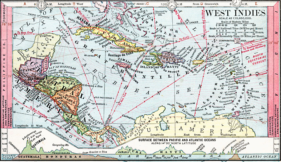
Description: A map from 1872 of the West Indies and Central America. The map shows political boundaries at the time, capitals, major cities, and ports, railroads, main steamship routes, rivers, terrain and coastal features, and banks. The map shows currents with direction of flow indicated by arrows and isotherms of mean annual temperature in degrees Fahrenheit. The steamship routes are marked to show travel times based on a speed of 15 miles per hour. Comparative latitudes and temperatures are given in the side margins, and clock symbols at the top of the map indicate times based on 12:00 noon, Greenwich. Longitudes from Greenwich are shown at the top of the map, longitudes from Washington at the bottom. A chart at the bottom of the map shows a cross–section vertical profile of land elevations and water depths along latitude 14° 30' North from Champerico Guatemala on the Pacific to Martinique on the Atlantic.
Place Names: A Regional Map of North America, Bahamas, �Island of Hayti,�Hayti, �San Domingo, �Jamaica, �Porto Rico, �Lucayos Isles, �Greater Antilles, �Lesser Antilles, �Windward Isles, �Leeward Isles,�Cuatemala, �Balize, �Honduras, �San Salvador, �Nicaragua, �Costa Rica,
ISO Topic Categories: boundaries,
location,
inlandWaters,
oceans,
elevation,
climatologyMeteorologyAtmosphere,
transportation
Keywords: West Indies and Central America, physical, �political, �transportation, �hydrological, kCaribbean, kCentralAmerica, physical features, country borders, water routes, currents, boundaries,
location,
inlandWaters,
oceans,
elevation,
climatologyMeteorologyAtmosphere,
transportation, Unknown, 1872
Source: James Monteith, Comprehensive Geography (New York, NY: A. S. Barnes and Company, 1872) 51
Map Credit: Courtesy the private collection of Roy Winkelman |
|