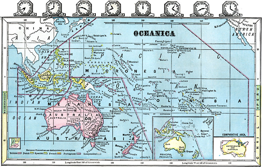
Description: A map from 1872 of Oceanica and the Pacific between latitudes 35° N and 50° S, and longitudes 90° E and 90° W of Greenwich. This map shows cities and ports, rivers, lakes, terrain, coral reefs, and coastal features of the region. Oceanica is subdivided to show the territorial island groups of Malaysia, Melanesia or Australasia, Micronesia, and Polynesia. The map includes inserts showing principal products of the region, a land comparison of the United States and Australia, and an outline map of Indiana, Ohio, and Kentucky at the same map scale to show the comparative area size relationship. This map is color-coded to show the European possessions of Britain, Netherlands, Spain, France, and Portugal, and indicates the independent territories at the time. Clock symbols showing the time zones are given at the top of the map, and latitude references to Madagascar, Peru, and Chile are given on the sides.
Place Names: Regional Pacific Ocean, Australia, �New Zealand, �Papua New Guinea, �Solomon Islands, �Hawaiian Islands, �Sandwich Islands, �Federated States of Micronesia, �French Polynesia, �Oceani
ISO Topic Categories: physical, �political, kComparativeArea, kWorldPacific
Keywords: Oceanica, physical, �political, kComparativeArea, physical features, country borders, physical, �political, kComparativeArea, kWorldPacific, Unknown, 1872
Source: James Monteith, Comprehensive Geography (New York, NY: A. S. Barnes and Company, 1872) 86
Map Credit: Courtesy the private collection of Roy Winkelman |
|