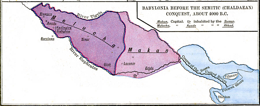
Description: A map of Babylonia, in current Iraq, before the Semitic (Chaldaean) Conquest, about 4000 B.C. This map shows the early territories of Makan and Melucha between the rivers Tigris and Euphrates, with the Makan capital Ur inhabited by the Sumer tribe and the Meluchan capital Agade inhabited by the Akkan tribe. The map shows important historical cities, and the past and present shoreline of the Persian Gulf at the mouth of the united Tigris and Euphrates rives, showing that the site of the city of Basra was once under water. "At the place where the two rivers approach each other most nearly (about four hundred miles from their present mouth) there commences a rich plain which consists entirely of the soil deposited by the rivers in a long, narrow arm of the sea. At the dawn of history the greater part of this arm had been filled up as far as 31 northern latitude. The plain extends, at present, one degree farther south. This plain was, in very early times, one of the most productive and thickly populated countries. Here was the center and starting-point of that civilization which afterward spread throughout Western Asia. It was inhabited by several cognate tribes, entirely unconnected with the nations of Western Asia. [...] Originally in Makan, the southern part of the plain, we find the Sumerians (Sumer), with the capital Ur on the Euphrates, and in Melucha, the northern part, we find the Akkadians, so called after their capital, Akkad (Agade)." — Labberton, 1886, pp. 4-5.
Place Names: Iraq, Makan, �Meluch
ISO Topic Categories: oceans,
location,
inlandWaters
Keywords: Babylonia Before the Semitic (Chaldaean) Conquest, borders, oceans,
location,
inlandWaters, Unknown, about 4000 BC
Source: Robert H. Labberton, New Historical Atlas and General History (New York, NY: Townsend Mac Coun, 1886) Plate I
Map Credit: Courtesy the private collection of Roy Winkelman |
|