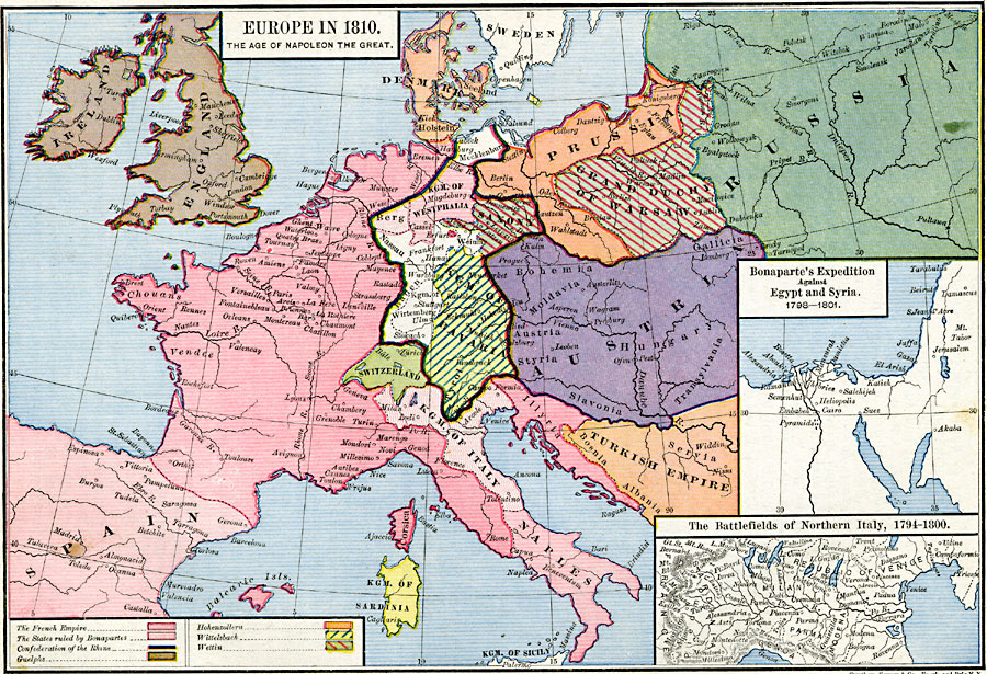
Description: A map of Europe in 1810, subtitled "The Age of Napoleon the Great." This map is color–coded to show the territories and possessions in Europe of the time, including the French Empire, the states ruled by Bonaparte, the Confederation of the Rhine, and the lands of the House of Guelphs, Hohenzollern, Wittlelsbach, and Wettin. This map also shows England, Denmark, Mecklenburg, Prussia, Kingdom of Westphalia, Saxony, Grand Duchy of Warsaw, Kingdom of Würtemburg, Kingdom of Bavaria, Switzerland, Austria, Spain, Corsica, Kingdom of Italy, Illyria, Kingdom of Sardinia, and Naples. The map also shows portions of Russia and the Ottoman Empire. Major rivers and important cities of the time are shown. Inset maps detail Napoleon's expedition against Egypt and Syria in 1798–1801, and the battlefields of Northern Italy between 1794 and 1800.
Place Names: Western and Central Europe, Bavaria, �England, �Ireland, �Italy, �Prussia, �Russia, �Saxony, �Spain, �Switzerland, �Turke
ISO Topic Categories: oceans,
location,
inlandWaters,
boundaries
Keywords: Europe in the Time of Napoleon, borders, �political, kNapoleonBonaparte, kNapoleonicWars, country borders, oceans,
location,
inlandWaters,
boundaries, Unknown, 1810
Source: Robert H. Labberton, New Historical Atlas and General History (New York, NY: Townsend MacCoun, 1886) Plate L
Map Credit: Courtesy the private collection of Roy Winkelman |
|