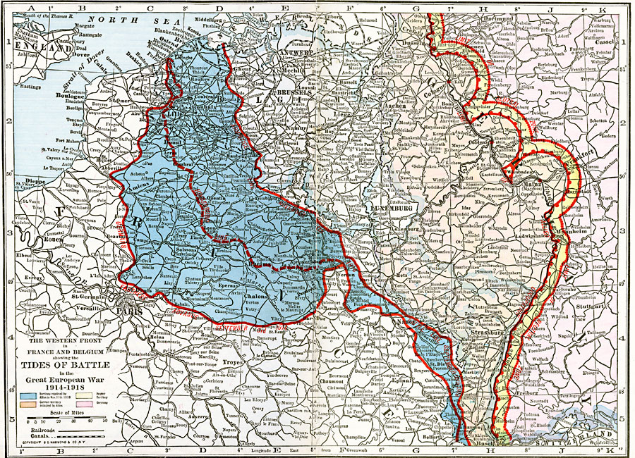
Description: A map of the western front in France and Belgium showing the tides of battle in the Great European War in 1914–1918, including the line of furthest advancement by the Germans into France on September 3, 1914, the Hindenburg Line from whence the Germans began their final push towards Paris in 1918, the Armistice Line of November 11, 1918, the line of Allied occupation along the Rhine River, and the neutral zones. The map is color–coded to show the territory regained by the Allies in 1918, the German territory occupied by the Allies, the neutral zone, and the German territory after November 11, 1918. The map shows capitals, cities, towns, ports, railways, canals, and major rivers of the region.
Place Names: Western and Central Europe, Antwerp, �Belgium, �Brussels, �France, �Lille, �Luxemburg, �Rheim
ISO Topic Categories: oceans,
location,
inlandWaters
Keywords: The Western Front in France and Belgium, borders, �political, �historical, �transportation, kWWI, country borders,
major political subdivisions, railroads,
water routes, historical event,
other military, oceans,
location,
inlandWaters, Unknown, 1914–1918
Source: , The New Reference Atlas of the World - A New Series of Physical, Political and Historical Maps compiled from Government Surveys and exhibiting the Latest Results of Geographical Research (New York, NY: C. S. Hammond & Company, 1920) 36-37
Map Credit: Courtesy the private collection of Roy Winkelman |
|