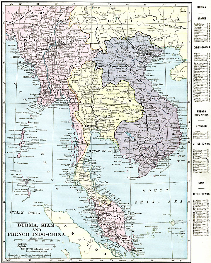
Description: A map from 1920 of Burma, Siam, and French Indo-China at the time. The map shows the British possessions of British India (extending to Assam and Burma, or Myanmar) and the Federated Malay States (under protectorate of Britain) in pink, Siam or Thailand in yellow, and French Indo–China possessions, including Tonkin, Annam, Laos, Cambodia, and Cochin China, in purple. The map shows capitals and major cities and ports, railroads, lakes, rivers, coastal features, and islands of the region. A grid reference key shows the locations of states, political divisions, cities and towns for the region.
Place Names: Southeastern Asia, Bangkok, �Burma, �Cambodia, �Hanoi, �Indo-China, �Mandalay, �Myanmar, �Rangoon, �Saigon, �Siam, �Singapor
ISO Topic Categories: oceans,
location,
inlandWaters,
boundaries
Keywords: Burma, Siam, and French Indo-China, borders, �political, �transportation, �physical, topographical,
physical features, country borders,
major political subdivisions, railroads,
water routes, oceans,
location,
inlandWaters,
boundaries, Unknown, 1920
Source: , The New Reference Atlas of the World - A New Series of Physical, Political and Historical Maps compiled from Government Surveys and exhibiting the Latest Results of Geographical Research (New York, NY: C. S. Hammond & Company, 1920) 59
Map Credit: Courtesy the private collection of Roy Winkelman |
|