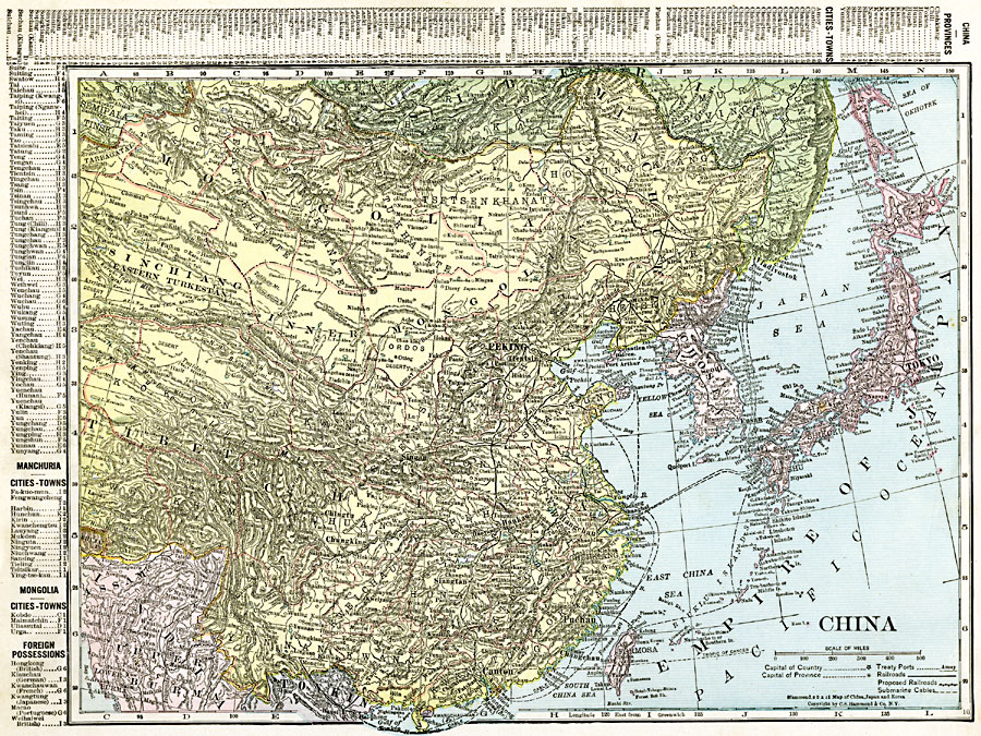
Description: A map from 1920 of China and the Empire of Japan at the time. The map shows political boundaries and foreign possessions, capitals, provincial capitals, major cities, treaty ports, existing and proposed railroads, canals, submarine telegraph cables, mountain systems, plateaus, basins, deserts, lakes, rivers, coastal features, and islands. The map shows Japanese possessions in pink, including Chosen (Korea), the southern Liaodong Peninsula around Port Arthur, the eastern Shantung Province, the former German territory of Kiauchau (Qingdao or Tsingtao), the Riukiu (RyuKyu) Island chain, and Formosa (Taiwan). The map includes a grid–reference key along the margins of the provinces, cities, and towns of China, the cities and towns of Manchuria and Mongolia, and the foreign possessions in China.
Place Names: China, Beijing, �Chengdu, �Chungking, �Lanzhou, �Lhasa, �Manchuria, �Nanjing, �Shanghai, �Shenyang, �Urumqi, �Wuhan, �Zhengzo
ISO Topic Categories: oceans,
location,
inlandWaters,
boundaries
Keywords: China, borders, �political, �transportation, �physical, topographical,
physical features, country borders,
major political subdivisions, railroads,
water routes, oceans,
location,
inlandWaters,
boundaries, Unknown, 1920
Source: , The New Reference Atlas of the World - A New Series of Physical, Political and Historical Maps compiled from Government Surveys and exhibiting the Latest Results of Geographical Research (New York, NY: C. S. Hammond & Company, 1920) 62
Map Credit: Courtesy the private collection of Roy Winkelman |
|