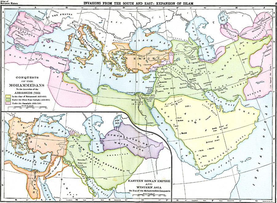
Description: A map of southern Europe, western Asia, and northern Africa showing the conquests of the Mohammedans from the time of Mohammed (622-632 BC) to the accession of the Abbassids (750 BC). This map is color-coded to show the Islamic territories at the time of Mohammed in yellow, the territories under the first four Caliphs (632-661 BC) in green, the territories under the Ommaids (661-750 BC) in pink, and the territories of the Eastern Roman or Byzantine Empire in orange. The Kingdom of the Franks (including Asturia and Cantabria in the northern Iberian Peninsula) and the Kingdom of the Lombards are also shown. The Islamic territories at the time of Mohammed include the Great Nafud (Red Sand Desert), Nejd, Hedjaz, Bahrain, Yemama, Sandy Desert of Roba el-Khali, Oman, Yemen, Hadramaut, and Mahra. The Islamic territories under the Caliphs include Barca and coastal northern Africa, Misr (Egypt), Syria, Djezira (Mesopotamia), Arran, Djibal (Kurdistan), Khuzistan, Khorassan, Tukhristan, Fars, Sadjistan, and Kirman. The Islamic territories under the Ommaids include Armenia and Edessa, Djilan, Tabaristan, and Djurdjan on the Caspian Sea, Khuwarizm, Transoxiana, and Mukran to beyond the Indus River, Maghreb and Africa in northern Africa, and Andalusia on the Iberian Peninsula. Major cities and rivers of the time are shown. An inset map shows the extent of the Eastern Roman Empire and kingdoms of western Asia on the eve of the Mohammedan conquests, including the Kingdom of the Sassanids (Persia, 226-642 BC), Kingdom of the Ghassanids, Kingdom of the Lakhmids, Kingdom of Lazica, Kingdom of Iberia, and the territories of the Ephthalites or White Huns.
Place Names: Regional Miscellaneous, Africa, �Andalusia, �Arabia, �Babylon, �Bagdad, �Cairo, �Constantinople, �Djezira, �Jerusalem, �Maghre
ISO Topic Categories: physical, �historical, kWorldMedSea, kWorldAfroAsia, kWorldEurasia, kWorldEuroAfrica
Keywords: Conquests of the Mohammedans , physical, �historical, county borders, historical event,
other military, physical, �historical, kWorldMedSea, kWorldAfroAsia, kWorldEurasia, kWorldEuroAfrica, Unknown, 750– 622 BC
Source: , Dow's Atlas of European History (New York, NY: Bormay & Company, )
Map Credit: Courtesy the private collection of Roy Winkelman |
|