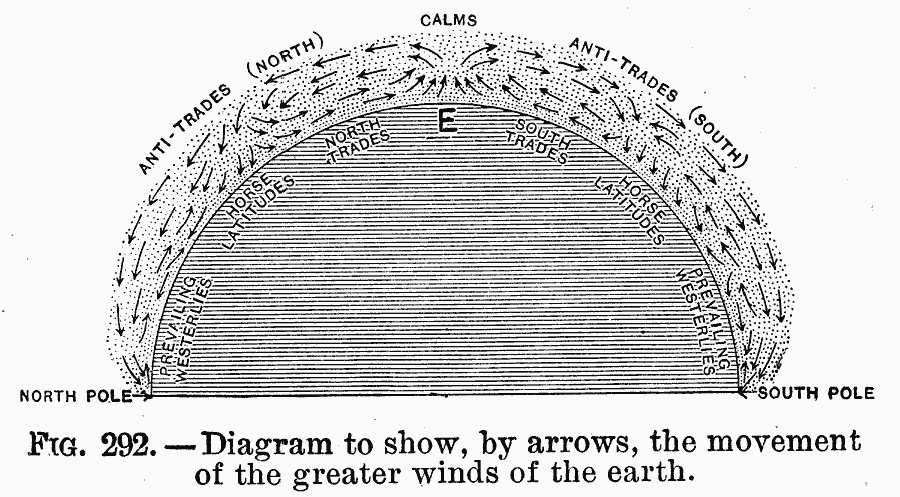
Description: A diagram from 1910 showing, by arrows, the movement of the greater winds of the earth. The perspective is a cross-section of the earth, with the North and South poles at the bottom of the hemisphere, and the equator (E) at the top. From the equator, the diagram shows the general surface regions of the trade winds, horse latitudes, and prevailing westerlies toward each of the poles. The diagram illustrates how warm air at the equator rises in the area of calms, drawing the surface air of the trade winds towards the equator. At higher elevations the winds cool and move toward the poles as the return trade or anti-trades. Approximately one third of the distance to the poles, the mid-level air descends in the region of calms at the horse latitudes and some circulates back to the equator. The upper level air continues to the poles and circulates as the prevailing westerlies at the surface.
Place Names: Miscellaneous, North Pole, �South Pol
ISO Topic Categories: climatologyMeteorologyAtmosphere
Keywords: Profile of the Earth's Greater Wind Patterns, meteorological, kClimate, winds, climatologyMeteorologyAtmosphere, Unknown, 1910
Source: Ralph S. Tarr, B.S., F.G.S.A. and Frank M. McMurry, Ph.D., New Geographies (Second Book) (New York , NY: The MacMillan Company, 1910) 207
Map Credit: Courtesy the private collection of Roy Winkelman |
|