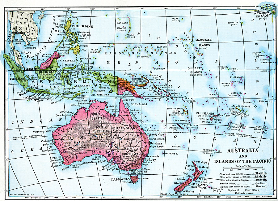
Description: A map of Australia, Australasia, and islands of the Pacific in 1910 covering the area roughly from Sumatra in the East Indies to longitude 160 West from Greenwich, including the Hawaiian Islands. This map shows major cities with populations from 50,000 to over 200,000, capitals, and ports. The map shows the territorial claims of European countries prior to WWI, including German Kaiser Wilhelms Land in New Guinea, Dutch claims in the East Indies, and Portugal in East Timor. The Philippines and Hawaiian Islands are under US control at the time of this map.
Place Names: Regional Pacific Ocean, Alice Springs, �Brisbane, �Cairns, �Canberra, �Darwin, �Mackay, �Melbourne, �Newcastle, �New Zealand, �Sumatra, �Sydney, �Tasmania, �Townsville, �Wale
ISO Topic Categories: physical, �transportation, �political, kWorldPacific
Keywords: Australia and Islands of the Pacific, physical, �transportation, �political, topographical, country borders, water routes, physical, �transportation, �political, kWorldPacific, Unknown, 1910
Source: Ralph S. Tarr, B.S., F.G.S.A. and Frank M. McMurry, Ph.D., New Geographies (Second Book) (New York , NY: The MacMillan Company, 1910) 390
Map Credit: Courtesy the private collection of Roy Winkelman |
|