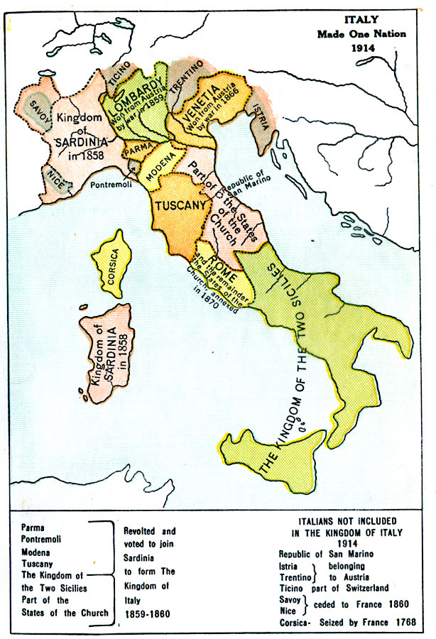
Description: A map of the Kingdom of Italy in 1914 subtitled "Made One Nation." This map shows the unification of Italy with dates and notations for annexation to the Kingdom of Sardinia (the founding state, which became the Kingdom of Italy in 1861). The states of Parma, Pontremoli, Modena, Tuscany, the Kingdom of the Two Sicilies, and part of the States of the Church revolted and voted to join Sardinia in 1859-1860. The map shows Lombardy won from Austria by war in 1859, and Venetia won from Austria by war in 1866. Rome and the remainder of the States of the Church are shown as annexed in 1870. The Italians not included in the Kingdom of Italy in 1914 are the Republic of San Marino, Istria and Trentino, which belonged to Austria (annexed to Italy in 1915 by the London Pact), Ticino, a part of Switzerland, Corsica, seized by France in 1768, and Savoy and Nice, ceded to France in 1860 as part of the unification effort under the Plombiéres Pact.
Place Names: Italy, Savoy, �Nice, �Sardinia, �Corsica, �Ticino, �Lombardy, �Parma, �Pontremoli, �Trentino, �Venetia, �Istria, �Modena, �San Marino, �Tuscany, �States of the Church, �Rome, �Two Sicilie
ISO Topic Categories: boundaries,
oceans,
location,
inlandWaters
Keywords: Italy, physical, �political, �historical, physical features, country borders,
major political subdivisions, boundaries,
oceans,
location,
inlandWaters, Unknown, 1914
Source: L. P. Benezet, The Story of the Map of Europe (Chicago, Illinois: Scott, Foresman and Company, 1916) 143
Map Credit: Courtesy the private collection of Roy Winkelman |
|