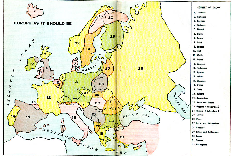
Description: A map created by the author to represent what he felt the layout of Europe should be in 1916 after WWI. "The chapter, entitled "Europe as it Should Be," with its accompanying map, shows the boundaries of the various nations as they would look if the bulk of the people of each nationality were included in a single political division. In many places, it is, of course, impossible to draw sharp lines. Greek shades off into Bulgar on one side and into Skipetar and Serb on the other. Prague, the capital of the Czechs, is one–third German in its population. There are large islands of Germans and Magyars in midst of the Roumanians in Transylvania. These are a few examples out of many which could be cited. However, the general aim of the chapter has been to divide the continent into nations, in each of which the leading race would predominate in population." — Benezet
Place Names: A Complete Map of Europe,
ISO Topic Categories: boundaries,
oceans,
location
Keywords: Europe "As it Should be", physical, �political, �historical, kEthnic, physical features, country borders, WWI, boundaries,
oceans,
location, Unknown, 1916
Source: L. P. Benezet, The Story of the Map of Europe (Chicago, Illinois: Scott, Foresman and Company, 1916) 246-247
Map Credit: Courtesy the private collection of Roy Winkelman |
|