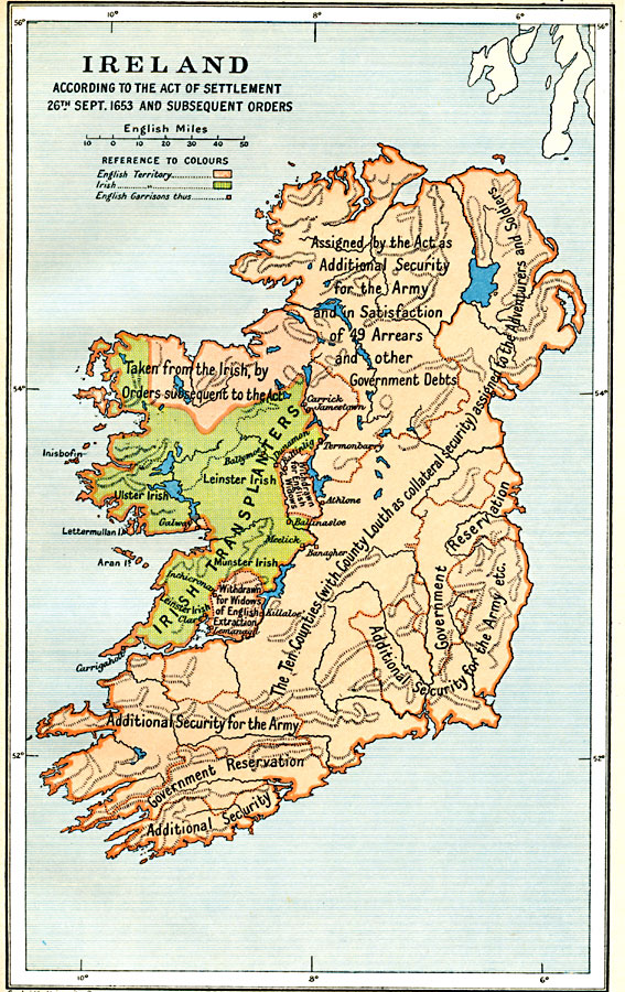
Description: Map of Ireland, according to the Act of Settlement 26th September, 1653 and subsequent orders. This map is color–coded to show English controlled territory in buff tint, and Irish territory in green. The English garrisons are shown, along with the general relocation areas of the Ulster, Leinster, and Munster Irish Transplanters. Several territorial map notations show where lands were "Assigned by the Acts as Additional Security for the Army and in Satisfaction of 49 Arrears and other Government Debts," "Taken from the Irish, by Orders subsequent to the Act," "Withdrawn for English Widows," "Withdrawn for Widows of English Extraction," "The Ten Counties (with County Louth as collateral security) assigned to the Adventurers and Soldiers," and the areas of Government Reservations and Additional Security.
Place Names: Ireland, Ireland, �Cork, �Dublin, �Foynes, �Galway, �Killarney, �Limerick, �Londonderry, �Monaghan, �New Ross, �Shannon, �Sligo, �Tipperar
ISO Topic Categories: oceans,
location,
inlandWaters,
boundaries
Keywords: Ireland according to the Act of Settlement , political, �historical, local jurisdictions,
country borders,
major political subdivisions, other military,
historical event, oceans,
location,
inlandWaters,
boundaries, Unknown, 1653
Source: Ward, Prothero, and Leathes, The Cambridge Modern History Atlas (New York, NY: The Macmillan Company, 1912)
Map Credit: Courtesy the private collection of Roy Winkelman |
|