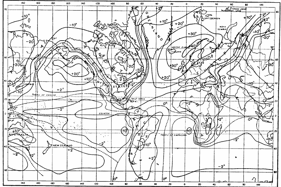
Description: A world map from 1896 showing the global isabnormal temperatures for January. "The irregular distribution of temperatures over the earth is best shown by considering the difference between the average temperature of each parallel and the actual temperature at places along the same parallel. These differences are called the abnormal temperatures of those places. The abnormal temperatures are charted, and the lines of equal magnitudes drawn on the charts are called is-abnormals...In the chart (Fig. 12), the minimum negative abnormal temperatures are -30° F. in northeastern Asia, between -20° and -30° F. in north-central North America, and -10° F. to the west of the middle latitudes of South America and the southern latitudes of Africa. The maximum positive abnormal temperatures are +40° F. off the western coast of Norrway, +20° F. of the southern coast of Alaska, and +10° F. in central Australia, southern South America, and southern Africa." — Waldo, 1896, pp.58-60.
Place Names: A Complete Map of Globes and Multi-continent, Africa, �Antarctica, �Asia, �Australia, �Europe, �North America, �South Americ
ISO Topic Categories: inlandWaters,
location,
oceans,
climatologyMeteorologyAtmosphere
Keywords: Isabnormal January Temperatures, physical, �meteorological, kClimate, physical features, temperature, inlandWaters,
location,
oceans,
climatologyMeteorologyAtmosphere, Unknown, 1896
Source: Frank Waldo, Elementary Meteorology (New York, New York: American Book Company, 1896) 58
Map Credit: Courtesy the private collection of Roy Winkelman |
|