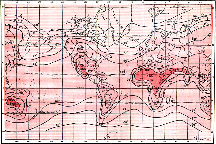
Description: A world map from 1896 showing the average maximum air temperatures for the year over the whole earth. Isotherms are drawn for each 9° Fahrenheit. "This chart shows that the maximum temperatures have a quite regular distribution on the oceans, where, for wide zones extending both sides of the equator, there is a maximum of about 86° F. ; and in no case does it reach 95° F. From these zones poleward there is a relatively rapid decrease with the latitude; and the temperature of 68° F. is reached near 60° latitude in the northern, and 50° latitude in the southern hemisphere. The continental distribution is quite different, however, for there an increase of the maximum temperatures takes place with the progress inland. In the interior of northern Africa, Persia, northern India, Australia, and southern North America, temperatures of 113° F. are to be found; and in the southwestern United States, and perhaps in the Sahara desert, they even reach 122° F. At high altitudes the extreme ranges of the maxima are less than on the lowlands, and are thus more like those for marine localities." — Waldo, 1896, pp. 63-65.
Place Names: A Complete Map of Globes and Multi-continent, Africa, �Antarctica, �Asia, �Australia, �Europe, �North America, �South Americ
ISO Topic Categories: climatologyMeteorologyAtmosphere,
inlandWaters,
location,
oceans
Keywords: Maximum Mean Annual Temperatures, physical, �meteorological, kClimate, physical features, temperature, climatologyMeteorologyAtmosphere,
inlandWaters,
location,
oceans, Unknown, 1896
Source: Frank Waldo, Elementary Meteorology (New York, New York: American Book Company, 1896) 64
Map Credit: Courtesy the private collection of Roy Winkelman |
|