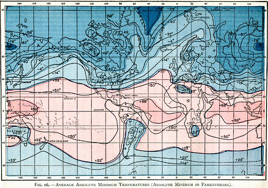
Description: A world map from 1896 showing the average minimum air temperatures for the year over the whole earth. Isotherms are drawn for each 9° Fahrenheit. "This chart shows very strongly marked regional characteristics. On the Pacific, Atlantic, and Indian oceans, in the equatorial region, there are extensive zones stretching from west to east, in which the minimum temperatures do not go below 68° F. To the north of these there is a rapid decrease in the minimum temperatures, but to the south it is not so rapid. There is a rapid decrease towards the interior of the continents, and especially where exist mountain ranges to cut off the access of the sea air to the interior. In the northern hemisphere there are three centers of extreme minimum temperatures — one in the eastern part of Siberia, another in the northern part of North America, and a third in the interior of Greenland. The 32° F. is very interesting as showing the limits of the region in which the freezing point of water is reached. In the northern hemisphere, commencing at the Yellow Sea, we can follow its easterly course with a northern bend on the Pacific Ocean, cutting North America at about latitude 30°. On the Atlantic Ocean, following the Gulf Stream for a distance in a northeasterly direction, it reaches almost to Ireland, when it takes a southeasterly trend, and passes along the coast of the Spanish peninsula. Continuing through the Mediterranean Sea, it passes through southern Asia to the place from which we started in tracing it. In the southern hemisphere it makes almost a loop within the continent of Australia, and passes from its southeastern corner in an easterly direction through northern New Zealand, and thence onward until the southern end of South America is almost reached; but stopping short of it, the line suddenly makes a northward curve up along the coast to about latitude 20° south, where it crosses the continent, and then runs southward again along the eastern coast to latitude 45° south, and thence takes an easterly course to the southern end of Australia. ." — Waldo, 1896, pp. 65-67.
Place Names: A Complete Map of Globes and Multi-continent, Africa, �Antarctica, �Asia, �Australia, �Europe, �North America, �South Americ
ISO Topic Categories: climatologyMeteorologyAtmosphere,
inlandWaters,
location,
oceans
Keywords: Minimum Mean Annual Temperatures, physical, �meteorological, kClimate, physical features, temperature, climatologyMeteorologyAtmosphere,
inlandWaters,
location,
oceans, Unknown, 1896
Source: Frank Waldo, Elementary Meteorology (New York, New York: American Book Company, 1896) 66
Map Credit: Courtesy the private collection of Roy Winkelman |
|