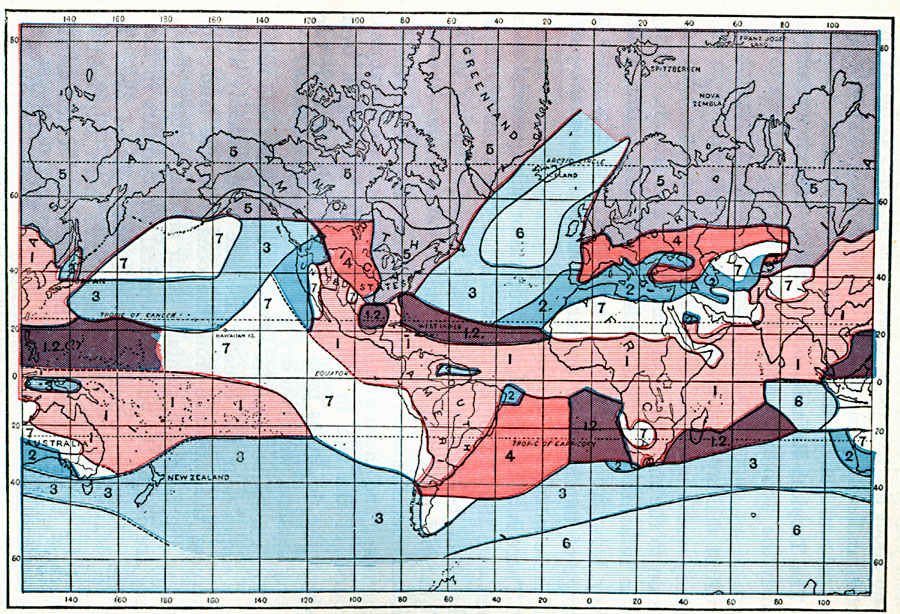
Description: A world map from 1896 showing seasonal rainfall distribution over the globe. This map is color-coded to show the major subdivisions, including the region of tropical rainfall (light pink), subtropical rainfall (dark blue), transition regions (dark purple), region of maximum rainfall in winter (medium blue), region of minimum rainfall in late summer (dark pink), region of moderate rain during all the months (light purple), wet region (light blue), and the dry region (white). The regions are numbered and described as (1) Tropical Rainfall, principal dry season in winter and spring; maximum rainfall in summer, (2) Subtropical Rainfall, maximum in winter; summer rainless, (1.2) Transition Region, rain winter and summer, (3) Region of Maximum Rainfall in winter, somewhat less rainfall in summer, (4) Region of Minimum Rainfall in late summer, with considerable rainfall at other seasons, (5) Region of Moderate Rain during all the months, with snow in winter, (6) Wet Region, copious rain during the whole year, but most rain in winter, and (7) Dry Region, all the months of the year deficient in rainfall.
Place Names: A Complete Map of Globes and Multi-continent, Africa, �Antarctica, �Asia, �Australia, �Europe, �North America, �South Americ
ISO Topic Categories: climatologyMeteorologyAtmosphere,
inlandWaters,
location,
oceans
Keywords: Global Rainfall Seasons, physical, �meteorological, kClimate, physical features, rainfall, climatologyMeteorologyAtmosphere,
inlandWaters,
location,
oceans, Unknown, 1896
Source: Frank Waldo, Elementary Meteorology (New York, New York: American Book Company, 1896) 151
Map Credit: Courtesy the private collection of Roy Winkelman |
|