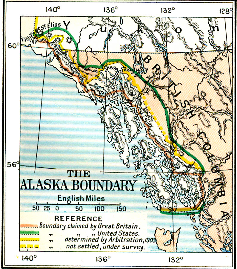
Description: A map of the northern Pacific coastland of North America showing the territorial dispute of the Alaska boundary from the Anglo–Russian Treaty of St. Petersburg in 1825 that established the British claims, the purchase of the area by the United States from Russia in 1867, and the boundary established by the Hay–Herbert Treaty between Britain and the United States in 1903. The map shows the coastline and fjords of the area, the gold rush jump–points of Skaguay, and Dyea, and the disputed Portland Canal to the south. When the United States purchased the Alaska territory from Russia in 1867, Canada claimed the ten leagues to be from the mouth of the fjords, while the United States claimed it from the head of the fjords, thus increasing the territory substantially to the east. During the Klondike Gold Rush, the dispute came to focus due to control of the Chilkoot Pass and White Pass from the coast into the goldfields. In 1903, arbitration was set up to settle the dispute, with a tribunal of three Americans, two Canadians, and one British. The British sided with the Americans (Hay–Herbert Treaty), a compromise was settled on, and the border was established between the two claims.
Place Names: A Regional Map of North America, Canada, �Newfoundland, �United State
ISO Topic Categories: oceans,
location,
inlandWaters,
boundaries
Keywords: The Alaskan Boundary Dispute, political, country borders,
local jurisdictions,
major political subdivisions, oceans,
location,
inlandWaters,
boundaries, Unknown, 1825–1903
Source: Ward, Prothero, and Leathes, The Cambridge Modern History Atlas (New York, NY: The Macmillan Company, 1912)
Map Credit: Courtesy the private collection of Roy Winkelman |
|