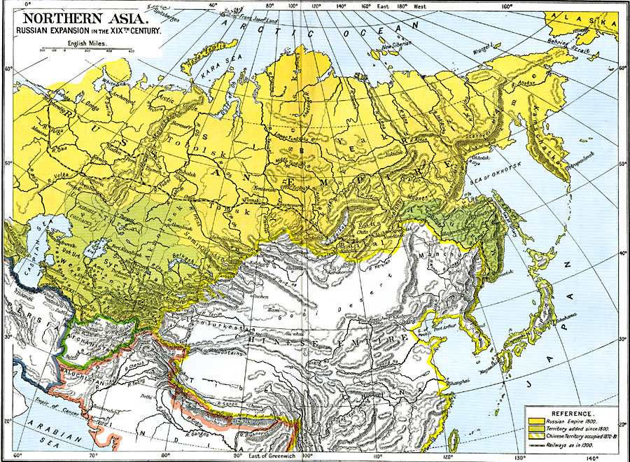
Description: A map from 1912 of Northern Asia showing the expansion of the Russian Empire into the region in the nineteenth century. The map is color-coded to show the extent of the Russian Empire in 1800, the territories added since 1800, and the Chinese territory occupied by Russia between 1870 and 1881. The map shows the railways in the region, including the Trans–Siberian Railway from St. Petersburg to its termination at Chita to the east of Lake Baikal. "Of the other great colonial Powers of earlier centuries, Russia alone was continuously active during the nineteenth century. In Central Asia she advanced her frontier southwards to meet Persia and Afghanistan, which now form buffer States between the Russian and British empires in Asia. In the Far East she advanced uninterruptedly until, attempting to encroach on China and find a better outlet to the sea, she was repulsed by Japan. [...] In the later eighteenth century, Russia was extending her control over the Kirghis hordes west of the Urals. In 1822, they were placed within the sphere of the Governors of Orenburg and Western Siberia. In 1842, the Amu Darya was brought under Russian influence; by 1853, the Sir Darya; by 1865, all the territory between the Aral Sea and Issik Kul. [...] From the barren regions of Kamschatka she moved southwards, in the nineteenth century. She gained control of the mouth of the Amur and of part of Saghalin Island, in 1854. By the Treaty of Aigun, in 1858, and a further convention, in 1860, she definitely acquired all the land on the left bank of the Amur and the sea–board so far south as the Tumen. Thus her frontiers touched Korea, and her territories half encircled Manchuria." — Ward, Prothero, and Leathes, 1912, pp. 109-110, 114.
Place Names: Miscellaneous Asia, Baikal, �Kemschatka, �Siberia, �Tomsk, �Turkesta
ISO Topic Categories: oceans,
location,
inlandWaters,
boundaries
Keywords: Russian Expansion in the 19th Century, political, �transportation, country borders,
local jurisdictions,
major political subdivisions, railroads, oceans,
location,
inlandWaters,
boundaries, Unknown, 1800s
Source: Ward, Prothero, and Leathes, The Cambridge Modern History Atlas (New York, NY: The Macmillan Company, 1912)
Map Credit: Courtesy the private collection of Roy Winkelman |
|