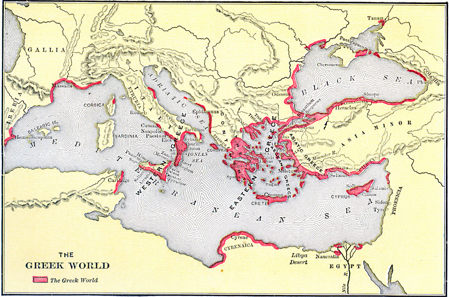
Description: A map of the Mediterranean and Black Sea region showing the extent of the Greek world at the end of their period of colonization. The map is color–coded to show the Greek settlements around the Aegean Sea and Anatolia, the shores of the Black Sea and Adriatic Sea, the islands of Cyprus and Crete, on the Nile delta, southern Italy and Sicily, Carthage in North Africa, northern Corsica, and coastal areas of France and Spain. "The great period of colonization which began about 750 B.C. came to an end two centuries later. The Greeks in this time had spread over a large part of the known ancient world, as the western Europeans have made their home in every part of the modern. [...] Greece, or Hellas, included all their settlements on the shores of the Mediterranean and its tributaries, from Egypt and Cilicia to the ‘Pillars of Hercules,’ and from south Russia to the Libyan desert. They were not united under a single government, but were one in blood, one in speech and manners, one in religion." — Botsford, 1912, pp. 39–40.
Place Names: Regional Mediterranean, Asia, �Europe, �Afric
ISO Topic Categories: physical, kAncientGreece, kWorldMedSea, kWorldAfroAsia, kWorldEurasia
Keywords: The Greek World, physical, kAncientGreece, physical features, physical, kAncientGreece, kWorldMedSea, kWorldAfroAsia, kWorldEurasia, Unknown, 550 BC
Source: George Willis Botsford, Ph. D., A History of Greece (London, : The Macmillan Company, 1912) 40
Map Credit: Courtesy the private collection of Roy Winkelman |
|